Having discovered the benefits of exercising outdoors during the Covid Lockdowns, many of us are keen to keep the momentum going. We have come to realise just how important outdoor physical activity is to our health and well-being.
If you would like to venture further afield to exercise in natural surroundings; to use walking tracks that will lead through our wonderful native forests, to visit a waterfall or a mountain creek hidden away from the roads, or off the beaten track, a lookout over a valley of tree ferns; – you should try bushwalking.
A bushwalk can be a short non-taxing way to exercise or an all-day strenuous workout, or anywhere in between, the choice is yours. If you want to go on your first bushwalk or start bushwalking regularly, a great way to start is to walk as with a bushwalking club. Clubs’ programs cater for all levels of fitness. They provide walks in a variety of locations, with differing time commitments, distances and degrees of difficulty. Clubs have experienced walk leaders among their members who do the planning and preparation, and know their walks.
Most Bushwalking Clubs welcome new bushwalkers, so please do not hesitate to contact one or more clubs that interest you to find out about how to join them as a guest on a walk or become a member. Most clubs affiliated with Bushwalking Victoria have their program of upcoming walks online. Have a look at the club programs from the list below. For a full list of clubs and their contact details, click here.
Mornington Peninsula Walks is so much more than a map: as well as being a comprehensive guide to many walks, it also offers a wealth of information to those wishing to explore this marvelous area which is easily accessible from Melbourne. Notes on flora and fauna, local history and public transport access are all provided. There is even a list of suggested reading and websites for visitors to the region. It is difficult to see what additional information could be packed into this publication.
Mornington Peninsula Walks (published Jan 2021) contains some information from the older Mornington-Arthurs Seat Map (2001), but has been so extensively updated and reworked that it is basically a new guide. It covers Point Nepean National Park, Mornington Peninsula National Park, Arthurs Seat State Park, Two Bays Walking Track and the Peninsula Coastal Walk.
Making a walk map of the Mornington Peninsula can be ‘awkward’ because a single map scale and orientation is not appropriate for all areas. Meridian has overcome this with two clever ideas: firstly, four of the six maps are printed at 1:25,000 and two at 1:20,000 (where more detail is required). Secondly, the two coastal walk maps are oriented across the page, rather than having north at the top. Clear north pointers are provided on all maps and the grid serves as a reminder to the map reader as to the map’s orientation. This enables the guide to be quite compact, whilst offering information-packed maps at a scale that is ideal for walkers.
Over two dozen walks are mapped and briefly described. Walk difficulty ratings (from easy to difficult), distances and times are provided. The times are generous, being equivalent to a walking speed of 2-3 kph, and range from one-hour family rambles to the rather more challenging 26km Two Bays Walking Track, with which many bushwalkers would be familiar. The information on the maps is comprehensive: parking and picnic areas, toilets and shelters, patrolled beaches, emergency marker locations, views and points of interest. The maps are peppered with interesting snippets of history and references to other recreational activities. A UTM grid is discretely under-laid on all maps for those wishing to use it; the 10m contour interval provides a good sense of the topography.
Printed copies of this publication can be purchased from local and online retailers and through Meridian Maps; all six maps are also available in georeferenced electronic form through the phone app Avenza. Having the electronic version of these maps and using the GPS capability of the phone means you always know exactly where you are. This is the beauty of having the maps available both as paper and on a phone app that has full navigational ability.
This publication is ideal for all types of visitors to the wonderful Mornington Peninsula – from a family that enjoys short walks during their holidays, through to serious bushwalkers who’d like to try an iconic Peninsula walk. Mornington Peninsula Walks is an invaluable resource; I have not seen any other walk publication of this area which is as detailed, easy to read or as comprehensive.
Review by Andrew Robinson
(Bushwalker, Camper, Mapping and Navigation trainer)
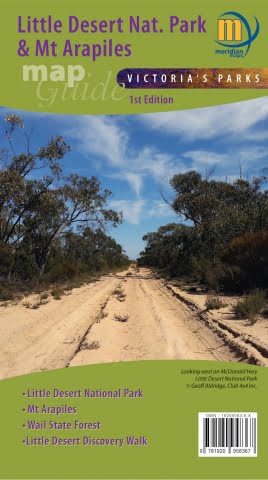
The popular Victoria’s Deserts 4WD Touring Map, now in its 5th edition, is a ‘must’ when planning a trip to the beautiful deserts of Victoria. Released in August 2020, this is the map I’d spread out on the table to research everything this area offers. The main map at 1:350,000 (that’s about 3mm representing each km) is essentially a road map; it extends from the Murray south past Horsham and west across the border into South Australia. It is packed with up-to-date detail on roads, tracks and camping sites and it also highlights tourist activities such as the Silo Art Trail. There is even a list of recommended reading for visitors to the region.On the reverse side of this large map are enlargements of seven popular areas, including Wyperfeld and Little Desert National Parks, Pink Lakes, Mt Arapiles and the northern Mallee. Scales of 1:100,000 (10mm per km) to 1:175,000 (about 6mm per km) are generally used; most walkers would find larger scales more helpful, although one could navigate from the enlargements at a pinch. Relief shading is used to illustrate topography, but, except for the Mt Arapiles map (1:50,000), no contours are shown – understandable on medium-scale maps of a relatively flat desert region. The grid is in Latitude/Longitude, which could be a challenge for those who use MGA grid references. These enlargements are also packed with clear, easy-to-read detail relevant to any visitor.
If the Little Desert, Mt Arapiles and the Wail State Forest are your areas of specific interest, then the new, smaller format Little Desert National Park & Mt Arapiles Map Guide is for you. Whilst essentially offering the same level of detail as the Victoria’s Deserts enlargements, these maps have slightly larger scales; the Mt Arapiles section is well-detailed at 1:20,000 and includes contours. These maps will interest walkers, as they show walking tracks in addition to vehicular tracks and roads. Again, lots of visitor information is included.
All of these maps are also available in georeferenced electronic form through the phone app Avenza. Once your trip planning’s completed using the paper map, you can hit the track with the electronic version. The GPS capability of the phone means you always know exactly where you are. This is the beauty of having the maps available both as paper and on a phone app which has full navigational ability. Interestingly, the electronic Little Desert map has an MGA-UTM grid overlayed, unlike the paper version.
As there are few maps of these fascinating areas, these publications would be an invaluable tool for those planning an adventure in this region post-COVID. As a bushwalker, when I’m on the track I prefer to use a large-scale map with contours and some indication of vegetation cover and other topographic features. However, for a touring or camping trip, I’d definitely use these paper maps for planning – this is where the Victoria’s Deserts maps really come into their own.
Andrew Robinson
(Bushwalker, Camper, Mapping and Navigation trainer)
“Practise, practise, practise’’ is a mantra well known to participants of Bushwalking Victoria’s Smartphone navigation course.
Bushwalkers appreciate the need to hone their skills if they want to use a GPS or smartphone as a navigation device in the bush. So they may have been surprised to recentlyread this article, about a walker who was lost while on a solo 4 day walk on the Arizona Trail, in an area with numerous side trails. We asked Andrew Robinson, presenter of the smartphone navigation course and map expert, to share his thoughts with us. Below is his take on it and some very handy tips!
Although an experienced bushwalker, Gary Morris was using a new GPS, a Garmin GPSMAP 64st, which he had only tried out once previously. This seems akin to purchasing a new 4WD and, after a brief tryout, embarking on a solo crossing of the Simpson Desert! The article implies that Morris was not using a map and compass as a back-up. After being rescued, Morris’ mapping software was blamed for him becoming lost; there was no acknowledgment that his lack of experience with the new device may have contributed.
COVID-19 lockdown is an ideal time to “Practise, practise, practise’’ while walking the streets within 5km of your home. You can’t really get lost there! Start by updating the software of your GPS/Smartphone. Many of the navigation apps, eg. Avenza, maps.me, Terra Map and many others, have added new features and updated their maps. You now have time to explore the online manuals and help files. It’s amazing what features and tricks you can find there. Then hit the streets and try navigating to waypoints, tracking, following a route, etc. This adds interest and enhances skills on the daily walk with the dog.
A couple of tips:
The compass on most GPS\Smartphones uses a magnetic sensor. Just as with a magnetic compass, those functions on the GPS/smartphone which use the magnetic sensor will be affected by metallic objects such as vehicles, metal fences, etc. These functions include the compass (obviously!), but also one which indicates direction of travel and one which orients the map in the direction of travel. In a few apps (e.g. Terra Map), one can switch from a magnetic compass to a ‘GPS’ one. Direction is then determined from GPS points, but this only works when one is moving.
Some GPS’s have a “Lock on Road” function. Turn it off! This function allows the GPS to lock its position pointer onto the nearest road or track. It can cause major confusion if there are lots of tracks in the area, or if you want to go off track. It is sometimes set ‘ON’ by default in a new GPS. Interestingly, Morris’ Garmin GPSMAP 64st had this feature: I wonder if he knew enough to turn it off.
Over recent years, many map producers have provided their map collections in electronic form. Only a limited number of these maps are available in a printed form. Geoscience Australia ceased printing its 1:250,000 topographical maps late in 2019. This is not a major problem for bushwalkers in Victoria: 1;250,000 (1cm to 2.5km) is not a scale most walkers use, because these maps provide insufficient detail. Good detailed maps covering Victoria at 1:25,000 (1cm to 250m) and 1:50,000 (1cm to 500m) are available in electronic form and many are also available as paper maps. These scales are far more useful out on the track.
Paper maps can be purchased from suppliers such as Vicmap (mainly 1:50,000), Spatial Vision and Meridian – see Finding Maps for Walking in Victoriafor a detailed list of sources, including shopfront and online suppliers.
If, rather than purchasing a paper map, you want to print one of the many electronic maps which are available from a variety of sources (including any of the Geoscience 1:250,000 maps) it’s relatively easy.
Many maps are produced in geopdf format. This allows the maps to be displayed and used in navigation software and apps e.g. Avenza. It also allows them to be easily printed to the correct scale using free software e.g. Adobe Acrobat reader. A walk leader can use an electronic map for navigation with their smartphone and carry the identical paper map.
Here are some options if you wish to have a printed copy of a geopdf map – either a whole map or part thereof.
Print the whole map:
Take the geopdf file to your local printer. It will cost about $20 for an A1 sheet and a little more if you want it on more robust waterproof paper, OR
Print the map as smaller tiles and stick them together. You can do this at home, using Adobe Acrobat reader. Open the required map, press ‘Print’ then press the ‘Poster’ button. Ensure ‘Tile Scale’ is on 100% and ‘Overlap’ is set at 1cm. ‘Cut marks’ should be checked to make putting the tiles together easier.
The preview screen will show how the map image will be tiled. Press print. Trim/assemble the sheets.
Print part of the map:
Open the map in Acrobat reader. Click on the ‘Edit’ menu and then ‘Take a Snapshot’. Highlight the desired area and press print. Press ‘Size’ and ensure ‘Actual size’ is checked. Your selected area will be shown in the middle of a sheet. If your selected area is larger than one sheet, you can poster print in tiles as described above.
What to do if you don’t have a colour printer:
Most modern computers can make a pdf file through the Print interface. Instead of printing to a physical machine, you can make a pdf file instead. Use the above instructions and just change the setting under ‘Printer’ to the pdf driver.
You can change the paper size to A3 under ‘Properties’ if you have a larger area to cover, or want bigger map tiles. Place the saved pdf file on a USB thumb drive and take it to your local self serve colour photocopier/printer.
Poster printing is a quick and cheap way to produce reasonable-quality larger maps from geopdf’s. You can use waterproof paper too, if you wish: ‘Rite in the rain 8512’ paper can be used in a laser printer; it’s about 30 cents an A4 sheet.
When printing from electronic maps, please remember to respect copyright. Personal use only.
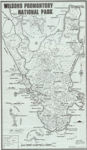
Exploring the Mysterious North East Corner of the Prom
Members of the Bayside Bushwalking Club took a walk on the wild side in March 2020, exploring the north-east corner of the Prom. Written by Paul Redmond.
The official ‘Park Notes’ for the Northern Section of Wilsons Promontory are quite discouraging. Walks’ Reports posted on the internet are not all that encouraging either.
This unlikely wilderness sits over there, across the flat country, to the east of the bitumen road to Tidal River. It beckons and tries to tempt the bushwalker with an inaudible siren call, “Turn your car into Five Mile Road and abandon that walk planned to commence at Telegraph Saddle”. We barely notice the grey/blue hills to the east. Your itinerant bushwalker remains aloof and never visits this mysterious north-east corner of the Prom.
Now, at long last, I have seen it first-hand and it is good.
The Northern Circuit is certainly not for the faint-hearted nor the unfit nor the unprepared. It is a hard walk done in long daily stages due to the distance between the relatively few campsites and the condition of the tracks. These remote camps are limited to six persons per night. There are limited assured water supplies and no Plan B optional routes. You are unlikely to meet anyone on the 60 km circuit. Some go clockwise others prefer the reverse. We went clockwise.
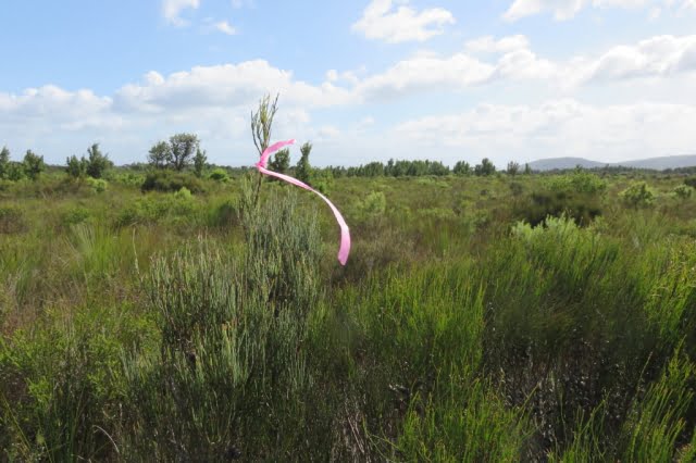
The majority of the circuit’s component tracks are overgrown and consequently hard to follow. You are pushing through dense scrub varying from knee-high to two metres and higher. There are numerous blind culs-de-sac caused by so many having gone astray at the same point, typically following a wombats’ runway, deviating around the prickles of Hakea or the points of a Xanthorrhoea or by just missing an unexpected right-angle turn. The tracks have more meanders than the Brisbane River. We lost the track quite often, but could quickly realise our error and recover, thanks mainly to the leader’s GPS or less technically, three pairs of eyes searching high and low for the elusive pink tapes that mark the true path of righteousness. These tapes vary from bright pink that contrasts clearly with the background, through to faded pale remnants that are hard to spot. New or old, they may be wrapped around a branch, high or low; flapping in the wind from a mere slip of a branch or tied to a juvenile trunk top that can barely support its own weight in the wind. You are never sure where to look.
The foot track, a narrow shallow groove in the ground, can be followed with care, but one cannot spend a whole trip staring at the ground. The scrub’s branches have grown over the track and they close ranks immediately behind the walker you are following, barely three metres in front. You can see where they are, but not how they got there. It was hard and tiring, constantly pushing through the scrub. Fortunately, most of the scrub we encountered had quite soft and flexible juvenile growth.
There is, however, plenty of resistant mature growth and hard deadwood with sharp broken ends to scratch an uncovered arm and sometimes draw blood on a covered arm with no damage to the protective sleeve. Compensating areas where the scrub is knee-high and not such hard work do exist, but even there the track can still be hard to follow. Being a wilderness area the signage is sparse; often old and faded.
Track Marker – But Where is the Track?
Being a wilderness area the signage is sparse; often old and faded.
Chinamans Long Beach
Five Mile Road is a closed Management Road that crosses the Prom running almost due east from near the southern reach of Corner Inlet. It is a tacit dividing line between the north and south sections of the Park. It is the way into and the way out of this wilderness.
We departed the car park on Five Mile Road at 1:30. The undulating gravel surface of the road eased us into the start of this expedition. The expansive views of Corner Inlet to our north-west (left) were revealed afresh at the top of each rise. Always in view is the scrubby flat country to the north-east which contains Chinamans Swamp and its marshy environs.
The undulation of the scrublands is relieved by many clumps of trees and small rises and typical Prom rocky outcrops. Mount Vereker (638m) and Five Mile Peak (475m) stay in view at the southern edge of the wilderness. Roundback Hill (314m), Mount Margaret (219) and Mount Hunter (348m) run to the north-east in a distant line. Mount Singapore (145m) is just visible at the northern tip of what J. Ros Garnet refers to as the Singapore Peninsula in his ‘History of Wilsons Promontory’.
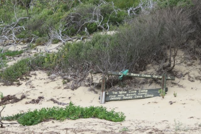
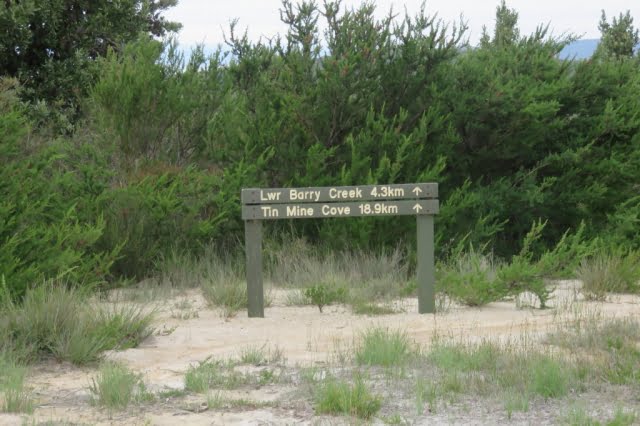
Descending a small rise, we see a green Parks’ sign planted in the sandy runoff beside the road, standing authoritatively in front of the dense scrub. It proclaims “Lower Barry Creek 4.3km” and “Tin Mine Cove 18.9km” with each notation accompanied by a broad arrow pointing to the sky. Good so far; but where is this sign-posted track. There is not even the slightest gap in that wall of scrub to indicate the track into the wilderness. After much examination of the area, eagle eyes recognised a change in the patterns in the sand revealing where to part the scrub and step through the curtain onto the track. Talk about “What’s behind the Green Door?”
And so we were into it. Not quite the great unknown, but if the entrance is a guide, who knows what this afternoon may bring.
The Track is Through There, …Somewhere
Two hours and twenty minutes (and 4.3 kms.) later, the party emerged from the scrub where the track crosses Barry Creek. A long stride across the leisurely flowing black tea coloured water, up the steep sandy bank and we were standing in the camp. When written down, the afternoon’s distance does not seem that much, but your author, for one, was very glad to reach the mysterious Lower Barry Creek Camp. I anticipated that this camp would be quite unlike the more familiar southern section camps that sprawl among the tea trees behind a beach. And it is; a small clearing hiding in the forest with just enough space to accommodate the regulation maximum of six walkers; in fewer tents.
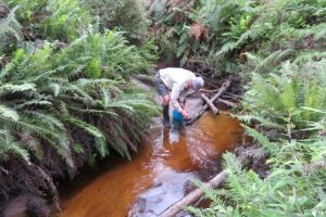
Dan collecting some ‘black tea’
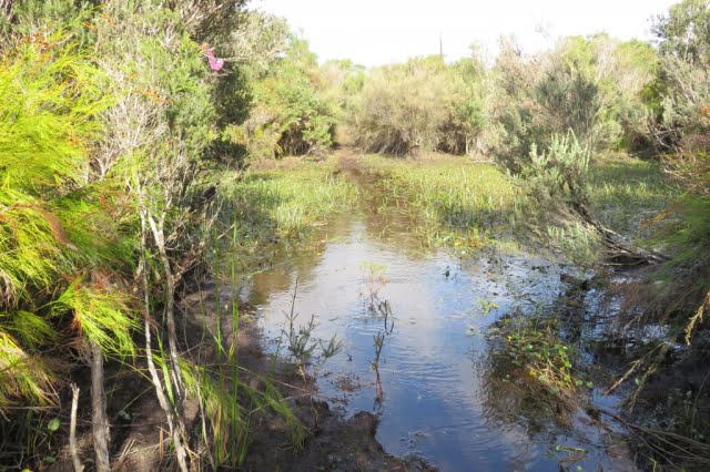
Mid-morning on day two saw us crossing the infamous Chinamans Swamp. We were lucky. Most of the swamp that we transited was just damp, squashy or even dry. The three recognisable water courses that crossed our appointed way were knee-deep in opaque muddy water that just hovered over an unseen, very soft and uneven bottom. It seemed as if we were walking along the creeks, not crossing them. No luxury of boardwalks in the wilderness.
It could have been worse. Horror stories of seemingly endless waist-deep swampy sections, are told by the intrepid who have passed through in wetter seasons. I was elated when I realised that we had just stepped up from our last quagmire. I exaggerate. It was more muddy water than watery mud, with green ribbon-like weed growing in the water and floating languidly on the surface.
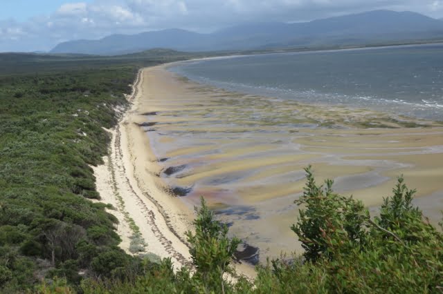
Having passed through the swamp, there was about one and a half hours through the difficult scrub to the southern end of Chinamans Long Beach. From the rises on the track we were treated to expansive views of the huge saucer which is drained by Chinamans Creek and Barry Creek into Corner Inlet. Track conditions gradually improved as we approached the beach, as scrub gave way to tea tree and the track surface gradually became sandy, indicating that the beach (and lunch) was not far ahead.
A gusty wind on the beach sent us back into the shelter of the foreshore tea tree for lunch. Anthony discovered Warragul Greens growing at our picnic spot, but no one moved to supplement their rations. A four kilometre walk on the wave compacted sand to the northern end of Chinamans Long Beach brought us to a track to take us above the rocks and the headland and around Tin Mine Hill to the Tin Mine Cove camp. We arrived at the respectable hour of three o’clock or thereabouts; this seemed to satisfy our leader’s desire for punctuality.
We braved the cold sea for a brief swim at the Tin Mine Cove beach. We could have used a swim yesterday afternoon at Lower Barry Creek Camp after the warm first afternoon.
Chinamans Swamp
The tracks pass through many sylvan patches of Banksia forest. A pleasure to pass through, to admire the gnarled old trees with bark-like hard old blue-grey leather, all splits and knobs They are such a contrast to the adjacent younger slimmer saplings, branching out abundantly with new growth displaying fresh green leaves. It is not all doom and gloom. There are sections of track that are easy to follow with no thorny flora, passively waiting to attack the labouring bushwalker.
Fortunately, the hills are gentle. The track, for all its shortcomings, has no replications of the long climb up to Telegraph Saddle or the knee destroying climb up to the Lighthouse precinct past the concrete helipad.
There were two precipitous descents on to beaches. If you had chosen the counter clockwise circuit, they would be very hard going as your feet slipped and sank into the loose sandy soil; handholds proving to be unattached to the soil, despite the appearance of security.
The scrub bashing was offset by two long beach walks – Chinamans Long Beach on the western side and Three Mile Beach on the eastern side. Beach walking is seen by some as boring, but there is pleasure in walking on a gently undulating beach, more or less in a straight line, except when searching for harder sand. I concede that a beach that slopes steeply from foreshore to waters’ edge is a pain in the downhill knee. If you are ambushed by a silent rogue wave as you walk the hard sand near the water’s edge, lost in a beachcombing reverie, it is a serious pain in the bottom. The beach sections were such a pleasant relief to the hard work pushing through the inland scrub with eyes constantly on the lookout for the next pink track marker and wary for reptiles basking on open sunny sections of track.
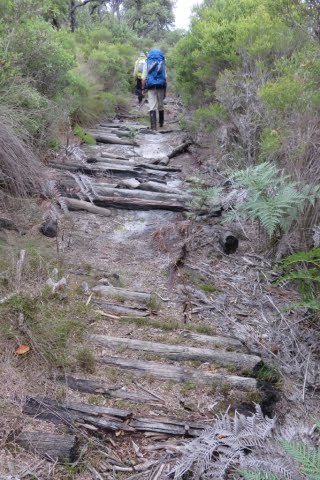
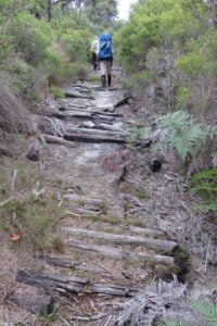
The track eastwards across the Prom, on day three, from Chinamans Long Beach to the lattice navigation light tower above Three Mile Beach was easy to follow for the most part. It had been cleared by Bushwalking Victoria volunteers about five years ago, but nature does not sit idle, another two to three years will see sections of the track all but disappear under the vigorous regrowth. Towards the middle of the crossing, a short length of the track is formed by an ancient corduroy surface. The logs forming the path are held in place by rusted steel cables secured to the logs by thin dog spikes. The substantial thick cables have deteriorated and parted from the logs whose charred ends showed that they had been burnt in a bushfire in years past. It is a relic of the bygone days when the track was formed for vehicles. Only a truck could have carried those cables to the site. Presumably, they were scavenged from the abandoned tin mine near Chinamans Beach (the short one north of Tin Mine Cove).
Day three included a brisk march along Three Mile Beach. Here, with their feet and trunks buried in the creamy coloured sand, the grey skeletons of large trees stand tall with an eerie starkness, against the green backdrop of the hills at the end of the beach. There are many reclining tree trunks lazing about, but they lack the gaunt starkness of the upright ghosts.
We lunched at the southern end of Three Mile Beach.
Three Mile Beach
Between Three Mile Beach and Johnny Souey Cove the track skirts around Three Mile Point which rises above the waves crashing in from the Southern Ocean onto the granite boulders with their coating of the endemic orange lichen. We discovered the hard way that there is more than one track around or indeed, over Three Mile Point. The main track which is clear and well defined eluded us as we fell to the temptation, after lunch, to take the first indication of a track. We followed some intermittent and elusive fading pink tags, heading uphill on an abandoned track which deteriorated to “route only”, a term I first saw on Duncan Brookes’ VMTC maps of walking areas in the High Country.
What remained of the track eventually disappeared from under our feet, leaving us pointed uphill and nowhere to go. The GPS would have told us, had it come equipped with a voice, that we should have walked a few metres further around the beach after lunch to where we would have easily picked up the cleared track – the track that did not climb high over the hill, but followed the contour around just above of the rocks and the waves.
To recover our position without retracing our steps, we compromised between blindly progressing over the hill towards Johnny Souey Cove and dropping directly towards the crashing waves. We did this by taking an oblique route down through the scrub towards our destination. This action slowly progressed our journey and brought us to the elusive well defined cleared track and the resultant increase in pace.
We ‘passed’ on an inspection of the Johnny Souey Cove campsite and pressed on in the luxury of a good cleared track over the divide separating the two bays. From our vantage point, we could see several runabout boats in the lee of Rabbit Island as well as between Monkey Point and Rabbit Rock.
As Anthony remarked, “No doubt those fishermen are looking up at us and wondering why people would choose to walk those hills with a load on their backs”. “They could be sitting down like us with some luxuries and no effort involved when you wish to relocate to another place where the fish could be biting”.
The day finished with a precipitous drop into Five Mile Beach. Low tide meant we could rock hop across Miranda Creek with dry boots. Camp was just off the beach.
A spring emptying into Miranda Creek delivered the best water of the trip; very weak black tea. The flow at the spring was quite strong, but most of it was inaccessible under rocks. The small flow that was available to the thirsty bushwalker was efficiently directed into water bottles by means of a short flexible plastic tube carried by one of our number for such a purpose.
Another swim – very cold; very brief.
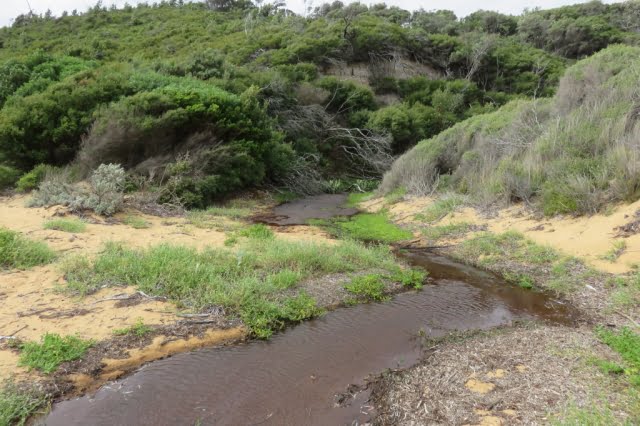
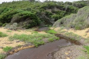
Fresh water was a potential problem for the entire trip and the advice had been to treat the second night’s camp at Tin Mine Cove as a dry camp; any potable water a bonus. We carried extra water for that camp, but it turned out that after Don filtered the local water, we had scored the bonus, even if there was a pronounced mineral taste to the water. Walk reports on the internet of trips early in 2020 gave mixed reports about the water supply at most campsites, but luckily we had no problems, apart from having to fight the undergrowth to get sufficiently upstream on Tin Mine Creek to reach the clearer faster-flowing water. Tin Mine Creek’s better water is not indicated by the coloured water lying limpidly across the beach, seeping into the sand and not quite reaching the water’s edge.
The campsites are small and there is a six-person per night limit. There are neither toilets nor the luxury of the piped water that constantly flows at the Sealers’, Waterloo or Refuge camps. Infuriatingly, toilet paper littered the outer perimeter of the camps; very disappointing. You would expect that the experienced walkers who venture into this wilderness area would be model citizens in the defecation department. Perhaps the boaties, who sometimes use the beachside camps, could be the culprits.
Tin Mine Creek
The weather, although mostly overcast, was kind to us.
From our vantage point at the Tin Mine Cove camp, in the afternoon and evening of day two, we could see rain showers heading across Corner Inlet from the southwest towards us. But for the most part, the rain moved around us, beyond our north-eastern side and we boiled our dinner water without resorting to parkas.
We were treated to overnight rain at the final camp at Five Mile Beach. Fortunately, we were able to dry our tents and pack up during a long break in the showers on the final morning. The weather on the westward walk across the Prom on the ‘management only’ Five Mile Track was showery for the most part. We three did not hesitate to bring out the pack covers, but there was no uniformity in the donning and removal of parkas as the intermittent showers of varying intensity, passed over us. Happily, the sun emerged for the last hour of that 18km crossing, so that we finished our journey warm and dry.
The author’s boots celebrated 11 years of existence and 125,000 kms of uncomplaining service with the sole separating from one boot and its companion trying to separate on the other boot. Fortunately, the toe end of the soles stayed put. Anthony did an excellent job of binding the sole at the instep with gaffer tape (without my having to remove the boot) and with the instep strap on my gaiters assisting, my boots made it to the end of the road.
We took four days, but effectively it was three days, and 60 kms. The Northern Circuit is a very hard walk.
It is immensely satisfying to complete a hard walk and see new country, particularly so, after you have recrossed the car park, deposited the pack and removed your boots from the weary feet at the bottom of your weary legs.
For beauty and coastal views, the North-Eastern corner of the Prom is the rather plain sibling of the overused Southern Section, but beauty is only skin deep. Don’t be discouraged, give some serious thought to this Cinderella and be pleasantly surprised.
The Corduroy between Chinamans Long Beach and Three Mile Beach
Walkers:
Don:
Leadership and Navigation
Anthony:
Morale and Botany
Paul:
Timekeeper – Rests and Lunchbreaks
Day 1 (afternoon):
Five Mile Track, Walking track to Lower Barry Creek Camp:
11 km
Day 2:
Chinamans Swamp, Chinamans Long Beach to Tin Mine Cove camp:
13 km
Day 3:
Cross the peninsula from Chinamans Long Beach to Three Mile Beach and Johnny Souey Cove and on to Five Mile Beach camp:
18 km
Day 4 (morning):
Five Mile Track to Car Park:
18 km
Notes
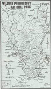
1. The Algona Guides ‘Map of Wilsons Promontory’ 1972 (price 20 cents) (see below) shows the track across the Prom between Chinamans Long Beach and Three Mile Beach as a vehicle track. This ‘cross Prom road is shown connecting to the rest of the world by a north/south road down the centre of the Singapore Peninsula, to the existing Five Mile Beach Road. The north/south road is now closed, even as a walking track.
2. A History of Wilsons Promontory National Park
Published electronically by the Victorian National Parks Association, May 2009
Members of the Bayside Bushwalking Club took a walk on the wild side in March 2020, exploring the north-east corner of the Prom. Written by Paul Redmond.
The official ‘Park Notes’ for the Northern Section of Wilsons Promontory are quite discouraging. Walks’ Reports posted on the internet are not all that encouraging either.
This unlikely wilderness sits over there, across the flat country, to the east of the bitumen road to Tidal River. It beckons and tries to tempt the bushwalker with an inaudible siren call, “Turn your car into Five Mile Road and abandon that walk planned to commence at Telegraph Saddle”. We barely notice the grey/blue hills to the east. Your itinerant bushwalker remains aloof and never visits this mysterious north-east corner of the Prom.
Now, at long last, I have seen it first-hand and it is good.
The Northern Circuit is certainly not for the faint-hearted nor the unfit nor the unprepared. It is a hard walk done in long daily stages due to the distance between the relatively few campsites and the condition of the tracks. These remote camps are limited to six persons per night. There are limited assured water supplies and no Plan B optional routes. You are unlikely to meet anyone on the 60 km circuit. Some go clockwise others prefer the reverse. We went clockwise.
The majority of the circuit’s component tracks are overgrown and consequently hard to follow. You are pushing through dense scrub varying from knee-high to two metres and higher. There are numerous blind culs-de-sac caused by so many having gone astray at the same point, typically following a wombats’ runway, deviating around the prickles of Hakea or the points of a Xanthorrhoea or by just missing an unexpected right-angle turn. The tracks have more meanders than the Brisbane River. We lost the track quite often, but could quickly realise our error and recover, thanks mainly to the leader’s GPS or less technically, three pairs of eyes searching high and low for the elusive pink tapes that mark the true path of righteousness. These tapes vary from bright pink that contrasts clearly with the background, through to faded pale remnants that are hard to spot. New or old, they may be wrapped around a branch, high or low; flapping in the wind from a mere slip of a branch or tied to a juvenile trunk top that can barely support its own weight in the wind. You are never sure where to look.
The foot track, a narrow shallow groove in the ground, can be followed with care, but one cannot spend a whole trip staring at the ground. The scrub’s branches have grown over the track and they close ranks immediately behind the walker you are following, barely three metres in front. You can see where they are, but not how they got there. It was hard and tiring, constantly pushing through the scrub. Fortunately, most of the scrub we encountered had quite soft and flexible juvenile growth.
There is, however, plenty of resistant mature growth and hard deadwood with sharp broken ends to scratch an uncovered arm and sometimes draw blood on a covered arm with no damage to the protective sleeve. Compensating areas where the scrub is knee-high and not such hard work do exist, but even there the track can still be hard to follow.
Track Marker – But Where is the Track?
Being a wilderness area the signage is sparse; often old and faded.
Chinamans Long Beach
Five Mile Road is a closed Management Road that crosses the Prom running almost due east from near the southern reach of Corner Inlet. It is a tacit dividing line between the north and south sections of the Park. It is the way into and the way out of this wilderness.
We departed the car park on Five Mile Road at 1:30. The undulating gravel surface of the road eased us into the start of this expedition. The expansive views of Corner Inlet to our north-west (left) were revealed afresh at the top of each rise. Always in view is the scrubby flat country to the north-east which contains Chinamans Swamp and its marshy environs.
The undulation of the scrublands is relieved by many clumps of trees and small rises and typical Prom rocky outcrops. Mount Vereker (638m) and Five Mile Peak (475m) stay in view at the southern edge of the wilderness. Roundback Hill (314m), Mount Margaret (219) and Mount Hunter (348m) run to the north-east in a distant line. Mount Singapore (145m) is just visible at the northern tip of what J. Ros Garnet refers to as the Singapore Peninsula in his ‘History of Wilsons Promontory’.
Descending a small rise, we see a green Parks’ sign planted in the sandy runoff beside the road, standing authoritatively in front of the dense scrub. It proclaims “Lower Barry Creek 4.3km” and “Tin Mine Cove 18.9km” with each notation accompanied by a broad arrow pointing to the sky. Good so far; but where is this sign-posted track. There is not even the slightest gap in that wall of scrub to indicate the track into the wilderness. After much examination of the area, eagle eyes recognised a change in the patterns in the sand revealing where to part the scrub and step through the curtain onto the track. Talk about “What’s behind the Green Door?”
And so we were into it. Not quite the great unknown, but if the entrance is a guide, who knows what this afternoon may bring.
The Track Is Through There, …Somewhere
Two hours and twenty minutes (and 4.3 kms.) later, the party emerged from the scrub where the track crosses Barry Creek. A long stride across the leisurely flowing black tea coloured water, up the steep sandy bank and we were standing in the camp. When written down, the afternoon’s distance does not seem that much, but your author, for one, was very glad to reach the mysterious Lower Barry Creek Camp. I anticipated that this camp would be quite unlike the more familiar southern section camps that sprawl among the tea trees behind a beach. And it is; a small clearing hiding in the forest with just enough space to accommodate the regulation maximum of six walkers; in fewer tents.
Don collecting some ‘black tea’
Mid-morning on day two saw us crossing the infamous Chinamans Swamp. We were lucky. Most of the swamp that we transited was just damp, squashy or even dry. The three recognisable water courses that crossed our appointed way were knee-deep in opaque muddy water that just hovered over an unseen, very soft and uneven bottom. It seemed as if we were walking along the creeks, not crossing them. No luxury of boardwalks in the wilderness.
It could have been worse. Horror stories of seemingly endless waist-deep swampy sections, are told by the intrepid who have passed through in wetter seasons. I was elated when I realised that we had just stepped up from our last quagmire. I exaggerate. It was more muddy water than watery mud, with green ribbon-like weed growing in the water and floating languidly on the surface.
Having passed through the swamp, there was about one and a half hours through the difficult scrub to the southern end of Chinamans Long Beach. From the rises on the track we were treated to expansive views of the huge saucer which is drained by Chinamans Creek and Barry Creek into Corner Inlet. Track conditions gradually improved as we approached the beach, as scrub gave way to tea tree and the track surface gradually became sandy, indicating that the beach (and lunch) was not far ahead.
A gusty wind on the beach sent us back into the shelter of the foreshore tea tree for lunch. Anthony discovered Warragul Greens growing at our picnic spot, but no one moved to supplement their rations. A four kilometre walk on the wave compacted sand to the northern end of Chinamans Long Beach brought us to a track to take us above the rocks and the headland and around Tin Mine Hill to the Tin Mine Cove camp. We arrived at the respectable hour of three o’clock or thereabouts; this seemed to satisfy our leader’s desire for punctuality.
We braved the cold sea for a brief swim at the Tin Mine Cove beach. We could have used a swim yesterday afternoon at Lower Barry Creek Camp after the warm first afternoon.
Chinamans Swamp
The tracks pass through many sylvan patches of Banksia forest. A pleasure to pass through, to admire the gnarled old trees with bark-like hard old blue-grey leather, all splits and knobs They are such a contrast to the adjacent younger slimmer saplings, branching out abundantly with new growth displaying fresh green leaves. It is not all doom and gloom. There are sections of track that are easy to follow with no thorny flora, passively waiting to attack the labouring bushwalker.
Fortunately, the hills are gentle. The track, for all its shortcomings, has no replications of the long climb up to Telegraph Saddle or the knee destroying climb up to the Lighthouse precinct past the concrete helipad.
There were two precipitous descents on to beaches. If you had chosen the counter clockwise circuit, they would be very hard going as your feet slipped and sank into the loose sandy soil; handholds proving to be unattached to the soil, despite the appearance of security.
The scrub bashing was offset by two long beach walks – Chinamans Long Beach on the western side and Three Mile Beach on the eastern side. Beach walking is seen by some as boring, but there is pleasure in walking on a gently undulating beach, more or less in a straight line, except when searching for harder sand. I concede that a beach that slopes steeply from foreshore to waters’ edge is a pain in the downhill knee. If you are ambushed by a silent rogue wave as you walk the hard sand near the water’s edge, lost in a beachcombing reverie, it is a serious pain in the bottom. The beach sections were such a pleasant relief to the hard work pushing through the inland scrub with eyes constantly on the lookout for the next pink track marker and wary for reptiles basking on open sunny sections of track.
The track eastwards across the Prom, on day three, from Chinamans Long Beach to the lattice navigation light tower above Three Mile Beach was easy to follow for the most part. It had been cleared by Bushwalking Victoria volunteers about five years ago, but nature does not sit idle, another two to three years will see sections of the track all but disappear under the vigorous regrowth. Towards the middle of the crossing, a short length of the track is formed by an ancient corduroy surface. The logs forming the path are held in place by rusted steel cables secured to the logs by thin dog spikes. The substantial thick cables have deteriorated and parted from the logs whose charred ends showed that they had been burnt in a bushfire in years past. It is a relic of the bygone days when the track was formed for vehicles. Only a truck could have carried those cables to the site. Presumably, they were scavenged from the abandoned tin mine near Chinamans Beach (the short one north of Tin Mine Cove).
Day three included a brisk march along Three Mile Beach. Here, with their feet and trunks buried in the creamy coloured sand, the grey skeletons of large trees stand tall with an eerie starkness, against the green backdrop of the hills at the end of the beach. There are many reclining tree trunks lazing about, but they lack the gaunt starkness of the upright ghosts.
We lunched at the southern end of Three Mile Beach.
Three Mile Beach
Between Three Mile Beach and Johnny Souey Cove the track skirts around Three Mile Point which rises above the waves crashing in from the Southern Ocean onto the granite boulders with their coating of the endemic orange lichen. We discovered the hard way that there is more than one track around or indeed, over Three Mile Point. The main track which is clear and well defined eluded us as we fell to the temptation, after lunch, to take the first indication of a track. We followed some intermittent and elusive fading pink tags, heading uphill on an abandoned track which deteriorated to “route only”, a term I first saw on Duncan Brookes’ VMTC maps of walking areas in the High Country.
What remained of the track eventually disappeared from under our feet, leaving us pointed uphill and nowhere to go. The GPS would have told us, had it come equipped with a voice, that we should have walked a few metres further around the beach after lunch to where we would have easily picked up the cleared track – the track that did not climb high over the hill, but followed the contour around just above of the rocks and the waves.
To recover our position without retracing our steps, we compromised between blindly progressing over the hill towards Johnny Souey Cove and dropping directly towards the crashing waves. We did this by taking an oblique route down through the scrub towards our destination. This action slowly progressed our journey and brought us to the elusive well defined cleared track and the resultant increase in pace.
We ‘passed’ on an inspection of the Johnny Souey Cove campsite and pressed on in the luxury of a good cleared track over the divide separating the two bays. From our vantage point, we could see several runabout boats in the lee of Rabbit Island as well as between Monkey Point and Rabbit Rock.
As Anthony remarked, “No doubt those fishermen are looking up at us and wondering why people would choose to walk those hills with a load on their backs”. “They could be sitting down like us with some luxuries and no effort involved when you wish to relocate to another place where the fish could be biting”.
The day finished with a precipitous drop into Five Mile Beach. Low tide meant we could rock hop across Miranda Creek with dry boots. Camp was just off the beach.
A spring emptying into Miranda Creek delivered the best water of the trip; very weak black tea. The flow at the spring was quite strong, but most of it was inaccessible under rocks. The small flow that was available to the thirsty bushwalker was efficiently directed into water bottles by means of a short flexible plastic tube carried by one of our number for such a purpose.
Another swim – very cold; very brief.
Fresh water was a potential problem for the entire trip and the advice had been to treat the second night’s camp at Tin Mine Cove as a dry camp; any potable water a bonus. We carried extra water for that camp, but it turned out that after Don filtered the local water, we had scored the bonus, even if there was a pronounced mineral taste to the water. Walk reports on the internet of trips early in 2020 gave mixed reports about the water supply at most campsites, but luckily we had no problems, apart from having to fight the undergrowth to get sufficiently upstream on Tin Mine Creek to reach the clearer faster-flowing water. Tin Mine Creek’s better water is not indicated by the coloured water lying limpidly across the beach, seeping into the sand and not quite reaching the water’s edge.
The campsites are small and there is a six-person per night limit. There are neither toilets nor the luxury of the piped water that constantly flows at the Sealers’, Waterloo or Refuge camps. Infuriatingly, toilet paper littered the outer perimeter of the camps; very disappointing. You would expect that the experienced walkers who venture into this wilderness area would be model citizens in the defecation department. Perhaps the boaties, who sometimes use the beachside camps, could be the culprits.
Tin Mine Creek
The weather, although mostly overcast, was kind to us.
From our vantage point at the Tin Mine Cove camp, in the afternoon and evening of day two, we could see rain showers heading across Corner Inlet from the southwest towards us. But for the most part, the rain moved around us, beyond our north-eastern side and we boiled our dinner water without resorting to parkas.
We were treated to overnight rain at the final camp at Five Mile Beach. Fortunately, we were able to dry our tents and pack up during a long break in the showers on the final morning. The weather on the westward walk across the Prom on the ‘management only’ Five Mile Track was showery for the most part. We three did not hesitate to bring out the pack covers, but there was no uniformity in the donning and removal of parkas as the intermittent showers of varying intensity, passed over us. Happily, the sun emerged for the last hour of that 18km crossing, so that we finished our journey warm and dry.
The author’s boots celebrated 11 years of existence and 125,000 kms of uncomplaining service with the sole separating from one boot and its companion trying to separate on the other boot. Fortunately, the toe end of the soles stayed put. Anthony did an excellent job of binding the sole at the instep with gaffer tape (without my having to remove the boot) and with the instep strap on my gaiters assisting, my boots made it to the end of the road.
We took four days, but effectively it was three days, and 60 kms. The Northern Circuit is a very hard walk.
It is immensely satisfying to complete a hard walk and see new country, particularly so, after you have recrossed the car park, deposited the pack and removed your boots from the weary feet at the bottom of your weary legs.
For beauty and coastal views, the North-Eastern corner of the Prom is the rather plain sibling of the overused Southern Section, but beauty is only skin deep. Don’t be discouraged, give some serious thought to this Cinderella and be pleasantly surprised.
The Corduroy between Chinamans Long Beach and Three Mile Beach
Walkers:
Don:
Leadership and Navigation
Anthony:
Morale and Botany
Paul:
Timekeeper – Rests and Lunchbreaks
Day 1 (afternoon):
Five Mile Track, Walking track to Lower Barry Creek Camp:
11 km
Day 2:
Chinamans Swamp, Chinamans Long Beach to Tin Mine Cove camp:
13 km
Day 3:
Cross the peninsula from Chinamans Long Beach to Three Mile Beach and
Johnny Souey Cove and on to Five Mile Beach camp:
18 km
Day 4 (morning):
Five Mile Track to Car Park:
18 km
Notes
1. The Algona Guides ‘Map of Wilsons Promontory’ 1972 (price 20 cents) (see below) shows the track across the Prom between Chinamans Long Beach and Three Mile Beach as a vehicle track. This ‘cross Prom road is shown connecting to the rest of the world by a north/south road down the centre of the Singapore Peninsula, to the existing Five Mile Beach Road. The north/south road is now closed, even as a walking track.
2. A History of Wilsons Promontory National Park
Published electronically by the Victorian National Parks Association, May 2009
Bushwalking Victoria calls for logging to be suspended in all native forests until a full and proper assessment of the impact of the bushfires is completed, including loss of habitat and impact on biodiversity of flora and fauna.
Very large areas of forests have been burnt and large number of native animals killed. This has had major impacts on native plants and animals, including threatened species and their habitat.
Logging of significant old growth native forest is proceeding in the Kalatha Valley and elsewhere near Toolangi and Warburton in the Central Highlands close to Melbourne. These remaining forests are popular with bushwalkers, locals and tourists and they provide habitat vital for several threatened species including Leadbeaters possum, the Spot-tailed quoll and the Powerful owl.
Scientists including Professor David Lindenmayer and Dr Chris Taylor have also advised their research demonstrates that logging makes native forests more prone to fire. The safety of local communities and bushwalkers visiting forests must take precedence over commercial logging.
The salvage logging that is proceeding in some fire-affected forests in Gippsland will compromise the recovery of these forests and is destroying the remaining habitat of native animals that survived the bushfires. This must also be halted.
All logging in native forests should be suspended until rigorous and thorough scientific studies assessing the impact of the catastrophic 2019-20 bushfires in Victoria are completed.
Peter Campbell, Environment Spokesperson, Bushwalking Victoria
Bushwalking Victoria has published an updated Bushwalking Manual that provides guidelines and information for safe, enjoyable community-based volunteer bushwalking in Australia. The manual includes contributions from other state and territory peak bushwalking organisations.
Feedback and suggestions are welcome and can be provided using links on the feedback page.
While the chances of a snake bite are fairly low the consequences of a snake bite can be very serious or even fatal. Most venomous snake bites in Victoria are from tiger or brown snakes.
There are 100 to 200 severe cases of snake bite that need antivenom in Australia each year. Half of all cases involve people interfering with snakes and one in ten cases are snake handlers. More about statistics are here.
Snakes may occasionally be encountered while bushwalking. Unprovoked, snakes rarely attack humans. Therefore, do not disturb a snake in your path and alert other members of your party to give it a wide berth. Always wear stout footwear and be observant. Take particular care in warm weather, long grass, hollow logs, near water or rocks in sunny positions.Watch and look out when stepping over logs or gathering firewood.
Wear long trousers and/or gaiters in areas where snakes are prevalent. Snakes cannot hear but they can detect vibrations through the ground, so walking heavily (stomping) may warn them of your presence and encourage them to flee from your path. When camping, use a tent with an integral floor and always zip up the doors. Use a torch at night.
Recognition
While some victims know they have been bitten, some do not. Symptoms may appear 15 minutes to 2 hours after the bite and may be mild or severe, depending on the species and the bite. Symptoms include double vision, headache, nausea and vomiting, sweating, faintness, diarrhoea, chest pain, difficulty swallowing or breathing, swollen lymph glands in groin or armpit, drowsiness.
Treatment
Seek immediate medical help by calling 000 Emergency Services and advise the walker’s emergency contact person.
The principle of the treatment of snake bites is to slow the movement of the venom in the body down by keeping as STILL as possible and apply firm pressure at the entry point.
When it bites, a snake injects venom into tissue, not directly into your bloodstream. Venom then travels from tissue fluid into the lymphatic system and will eventually flow into veins then enter the bloodstream. Applying a pressure bandage around the location of the snake bite and immobilising the patient slows down the movement of lymph fluid.
The lower leg is the most vulnerable to a snake bite when bushwalking. When someone is bitten:
Immediately apply firm pressure over the bite site.
Lay the victim down and keep them calm and at complete rest.
Apply a broad firm bandage to the bitten area and around as much of the limb as possible, without removing clothing if this means moving the limb. Bandage as tightly as for a sprain and work up the limb to include the joint above the bite site. Bandages with indicators showing the compression applied are recommended.
Immobilize the limb with a makeshift splint.
Constantly observe the patient for shock and respiratory failure. Dispatch other members of the party with knowledge of your location to bring outside help to transport the patient.
If external help is unavailable, the best option is probably to rest for a day or two then proceed to the nearest civilisation taking care to minimize stress to the patient.
Do NOT remove bandages or splints on reaching medical care, the treating doctor will make that decision.
DO NOT deliberately disturb or try to kill a snake. DO NOT walk in sandals or thongs. DO NOT cut the location of the bite.
DO NOT wash the skin – traces of venom left behind might be needed by medical personnel to identify the snake
DO NOT apply an arterial tourniquet. DO NOT attempt to suck the poison from the site of the bite.