Posted on

Universal Truths of Hiking the Lerderderg – 2 Rescues and a Very Long Day

In the Victorian hiking community, there are a few universal truths about the Lerderderg National Park that some people learn the hard way. First up: the map will feel like it is lying to you. A 5km loop on paper easily sucks up the time, sweat, and leg-burn of a 20km walk on the flat.

It’s just brutal terrain. Many signs of a clear track disappears pretty fast, turning into steep, ugly 300-metre climbs up loose gravel spurs where you're basically guessing the way by spotting faded pink ribbons tied to trees.

Once you drop down into the gorge itself, you can forget about a trail entirely. It's can be hours of relentless rock-hopping, scrambling over boulders, and wading through freezing water that will test your ankles and your patience.

And phone signal?  Dicey at best.  If you didn't download offline maps, you could find yourself hiking blind.

The main truth about Lerderderg is that it doesn’t compromise. It's a wild, unforgiving place that loves to humble overconfident hikers, and you’re pretty much guaranteed to walk out with a few bruises, soaked boots, and a lot more respect for the bush.

Anyone who has spent time in the Lerderderg Gorge and Werribee Gorge near Bacchus Marsh knows they have a reputation for rough, unforgiving terrain. What catches people out, however, isn't just the steep climbs or the rocky riverbeds, it’s how quickly the environment changes. Heavy rains alter watercourses, footpaths wash away on loose scree, and a route that was straightforward a few seasons ago can quietly turn into a serious scramble.

Three incidents from this last weekend show exactly why you can never treat Lerderderg or Werribee Gorge as a routine outing.

Bunerong Bushwalking Club: A 5-Hour Walk Turns into 9 Hours

While many Victorian clubs were away at the annual Federation weekend, four members of the Bunerong Bushwalking Club used the opportunity to head out to MacKenzies Flat picnic reserve to preview the Lerderderg Gorge loop.

Previewing routes is standard club practice for good reason. Bunerong had run this exact circuit a few years back without issue, but they soon found that conditions on the ground had altered dramatically:

  • Submerged Crossings: Higher river levels had submerged the stepping stones walkers usually rely on, leaving the team with wet boots and socks from early in the trip.

  • Track Degradation: The steep inclines and declines throughout the gorge had deteriorated heavily, requiring far more cautious footwork and navigation than on previous outings.

  • Timeline Blowout: Even with an experienced, small party, a walk that used to run comfortably between 5 and 6 hours blew out to nearly 9 hours.

Because those four members took the time to scout the trail, the club was able to make the call: the track is simply not suitable for a general club trip right now. It is a credit to the leaders who volunteer their weekends to do this unglamorous legwork, keeping members off routes that have become unsafe.

High Angle Rescue at Grahams Dam - Lerderderg National Park

Just as Bunerong's hikers were navigating their swollen crossings and deteriorated trails, another party of four in Lerderderg found out how unforgiving the terrain can be when route-finding goes wrong.

Near Grahams Dam, the hikers mistook a side track for an alternate route. In the gorge, faint tracks often look like easy ways around river obstacles, only to funnel walkers straight up onto steep bluffs with no safe way back down. The group ended up stranded 50 to 60 metres up a sheer cliff face, in a life-theatening situation.

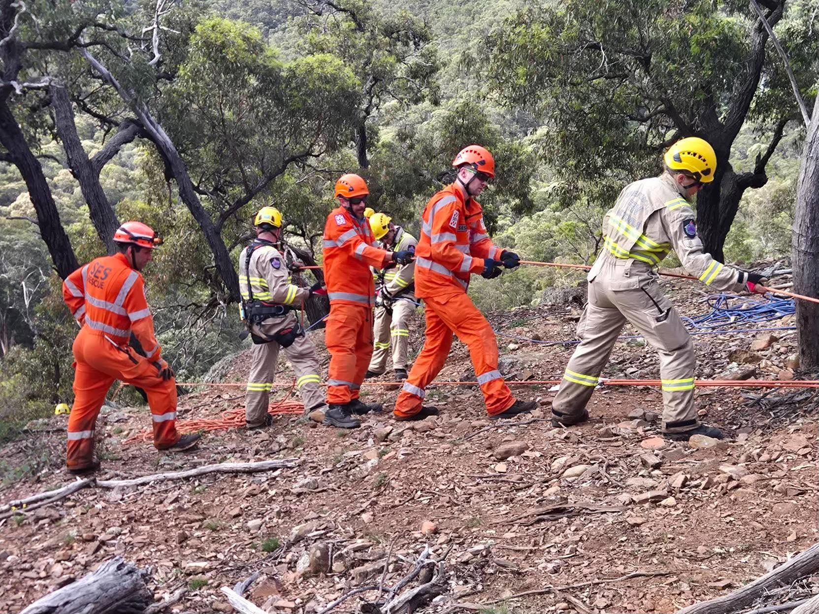
There was no walking them out. Rescuers had to deploy specialised high-angle rope systems to haul all four hikers up the cliff face to safety. The operation pulled in crews across multiple agencies, including the volunteers from the Bacchus Marsh SES, FRV, CFA, Ambulance Victoria, and Victoria Police.

Helicopter Extraction in Werribee Gorge

It wasn't just Lerderderg catching walkers out that weekend. Just down the road at Werribee Gorge, another hiker sustained a severe ankle injury.

In a lot of parks, a rolled ankle means a slow, painful walk out or a stretcher carry. But gorge terrain changes things. Due to the hiker's inaccessible location, ground crews couldn't safely extract them. After finding and stabilising the patient, Bacchus Marsh SES volunteer Search and Rescue crews and Ambulance Victoria Paramedics had to call in an Ambulance Victoria HEMS Helicopter to winch the patient out.

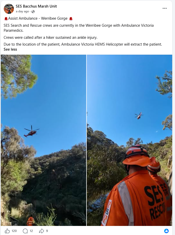
If there's one major takeaway from this weekend, it's the sheer pressure these incidents put on our local volunteer rescue crews. The SES Bacchus Marsh Unit was at the centre of the weekend's chaos. Replying to a local thanking them for their incredible work, the unit shared their call-out sheet. In just a 24-hour period, their volunteers responded to:

  • 2 Road Rescues

  • 2 Searches

  • 1 High Angle Rescue

As the unit rightly noted online, they were definitely "hoping for a bit of a rest!" Hikers owe it to these volunteers to be as prepared as possible so we don't add to their workload.

Lessons for Hikers and Group Leaders

Lerderderg and Werribee Gorges sit right on Melbourne’s doorstep, which often gives hikers a false sense of security. If you are planning a trip out that way, keep a few realities in mind:

  • Old trip notes expire quickly. Floods and erosion regularly shift gravel bars, wash out riverbanks, and erase markers. Don't rely on memory or a track log from three years ago.

  • Research your hike using multiple sources.  Don't just rely on a single map app, all trails, an instagram post or an old blog post. Cross-reference your plans by checking the Parks Victoria website for current closures or warnings, reading recent trip reports on walking forums, and looking at recent track logs on GPS apps. Combining official topographic maps with up-to-date, on-the-ground feedback gives you a much clearer picture of what you're actually walking into.
  • Previews matter. Bunerong’s experience proves the value of sending an experienced party out first. If a small, fit group takes nine hours on a six-hour trail, a larger  group will likely get caught out after dark.

  • Be wary of "easy" bypasses. When river levels are high, it’s tempting to scramble up valley walls to avoid deep water. That often leads onto crumbly, loose rock that dead-ends into a vertical drop.

  • A simple injury can mean a helicopter rescue. As we saw in Werribee Gorge, the steep, rocky terrain means you can't easily be stretchered out. Step carefully.  And make sure you have Ambulance Victoria membership.

  • Pack for the extra hours. If an unexpected trail blowout can add three to four hours to your day, head torches, extra food, adequate water, and an emergency communication device (like a PLB) aren't optional extras, even on a familiar loop.

  • Tell someone where you are going, what route you are taking, when to expect you to contact them, what equipment you are carrying, and where you have parked.  If you do need a rescue, this information can save rescuers hours of searching.

For comprehensive safety advice and trip checklists, check out the full safety guidelines on the Advice for Safe Bushwalking.

Find a Bushwalking Club.

Posted on

A Split Second in the Grampians: The Hollow Mountain Rescue

Story generously shared by Liesbeth Long, Founding President - Central Goldfields Bushwalking & Hiking Club Inc and Board Member - Bushwalking Victoria

In a split second our August monthly club hike in the Grampians went from a fantastic day exploring remote and rugged caves, to one I won’t forget in a hurry, when it turned into a major rescue operation after a rockfall left one of our hikers trapped and another seriously injured.

Our Central Goldfields Bushwalking and Hiking Club Inc had planned to visit a series of caves at Hollow Mountain in the Victoria Range as part of our monthly hike.

There was absolutely no anticipation that morning that anything would go wrong. It was a beautiful day, not a cloud in the sky, absolutely stunning. There was a bit of dew on the ground, but nothing major.

I was the sweep, so the last person making sure no one was left behind. As we got to the top of the mountain near the cave, I came around the last bend and heard an almighty scream, followed by a cloud of dust and stones, and I thought, ‘Oh my God, something serious has happened.’

While trying to enter the cave, the Hike Leader had accidentally dislodged a huge boulder. It rolled down and pinned a woman behind him, crushing her foot.

Then a second boulder knocked him off his feet. It landed on his chest, rolled onto his stomach and sat there, pinning him down.

He was just moaning and groaning. Two other hikers rushed up and managed to lift the rock off him. He sat up and was as white as a sheet. One of our members is a nurse and she stepped up and checked his vitals.

We looked at each other and I knew straight away that this was a serious incident and that we needed help immediately, so I pushed the button on the club’s Personal Location Beacons, (PLBs). Ours is a small yellow device (rescueME PLB Personal Locator Beacon) that sends a distress signal by satellite to the Joint Rescue Coordination Centre in Canberra. This can then alert emergency services to your exact location in an emergency.

IMG_0798

Our two club’s PLBs were donated through a grant from the Community Bank Avoca, Maryborough, St Arnaud when the club was founded 3 years ago, but they can also be purchased from outdoor and camping stores. PLBs are only to be used in grave danger. They are serious devices and its only one-way communication. The device is registered to our club, so our treasurer received a phone call at home asking, ‘One of your PLBs has gone off, what’s going on?’ She told them that the club had gone hiking in the Grampians.

I checked my phone and realised we had some mobile phone reception, so I then called Triple Zero and liaised with Emergency Services to co-ordinate a rescue of the injured hiker. An ambulance was immediately dispatched from Horsham.

From there, my actions prompted a cascade of emergency service responses. It became a multi-agency response involving Victoria Police, Ambulance Victoria, the State Emergency Service (SES), Fire Rescue Victoria (FRV) and six Country Fire Authority (CFA) units, including specialised rescue equipment brought in from Ballarat.

But of course, I didn't know any of this was happening at the time.

Once I explained what had happened, an Air Ambulance Victoria (HEMS4) helicopter was sent from Warrnambool. I knew we’d only a tiny spec to them, so asked people what they had in their packs to attract attention. We put down two aluminium foil thermal blankets on a ledge not far from us and started waving a bright coloured red jacket. They spotted us and made a beeline for us.

IMG_0800

As soon as the Paramedic had rappelled down, a police officer appeared out of nowhere. He was from Hamilton and had run up the mountain to find us. He was super fit, absolutely lathered in sweat, and had nothing on him except two bottles of water.

I was in constant contact with Emergency Services and they requested that two bushwalkers hike back to camp to meet with the rescue team so that they could show them where we were located. I called a ‘meeting’ and appointed the two most suitable people. It was challenging and I certainly had to think fast on my feet. It was so counter intuitive to split up our bushwalking group.

The Paramedic spent an hour with the injured man, administering IV pain meds and the ‘Green Whistle’. Meanwhile, the helicopter was hovering in a valley nearby. Once stable, the injured man was placed in a harness and gently walked down to the ledge following an impromptu path cleared by all of our hikers. The helicopter returned and they were both winched up. With a big sweeping bend they flew straight to the Alfred Hospital in Melbourne.

The accident happened at about 11am. I set off the PLB 15 mins later and rang 000 at 11.20am, the helicopter arrived at 12.30pm, and the injured man was hoisted out at 1.30pm. I honestly thought we would be there until dark, but it was only two and a half hours until he was in the air.

Two local CFA members then turned up. They had gone to the other ‘Hollow Mountain’ and that’s why they were so late. But between them and the police officer, they led our ‘somewhat bewildered’ party back down. When we eventually returned where we were base camping, we were met by four ambulances, two police cars and a CFA truck. There were people in uniform everywhere!

Paramedics went up to every single member of our group and asked, ‘What’s your name? What is your date of birth? Are you okay? Do you need anything?’

That night, there were seven of us left at camp and I thought everyone would just pack up and go home. Instead, everyone decided to stay. We sat around the fire, chatted and debriefed, which was really good for everyone and the group’s morale.

The next day, I floated the idea of going on a couple of small walks, one in the morning and one in the afternoon, because I didn’t want the previous day’s events to be the only memory of our weekend. Everyone agreed whole heartedly.

As confronting as the whole experience was, I don't think it should deter people from getting outdoors. Nature can be unpredictable, and this was a freak accident. Nobody was at fault and nobody was being careless.

What it did reinforce for me was the importance of being prepared for rare incidents like this. Even when there is mobile phone coverage, our club (and me personally), carry a PLB always and everywhere. It’s peace of mind for you and also your family.

As distressing as it was seeing people hurt, it was also fascinating to see how the emergency response system works. More importantly, it gave me real peace of mind knowing that if something goes wrong, there are systems in place to keep people safe.

Even so, I don't think you could ever really be prepared for something like this. I drew on all my leadership skills and then some, but everyone brought something to the table. I am incredibly proud of our group and the resilience and camaraderie everyone showed. People remained calm and followed instructions. Everyone worked together.

The injured man spent 4 days in ICU at the Alfred and is still recovering from seven broken ribs, a broken sternum, internal bleeding and two broken vertebrae in his back.

The other injured bushwalker suffered several broken bones in her foot but luckily didn’t require surgery – just a Moon Boot. She managed to hobble back down the mountain where she was assessed by paramedics.

Since then, we have all been ringing everyone to ask how we’re are going. That’s what our bushwalking club is about - being there for each other and supporting one another.

When I came home from our September club walk, my husband asked me how it went. I replied “It was great!” To which he responded, “What, no helicopters this time?”

No, but if I did need one, I know they are there at a moment’s notice - thanks to our incredible and dedicated emergency services!


Liesbeth Long

Founding President - Central Goldfields Bushwalking & Hiking Club Inc.

Board Member – Bushwalking Victoria

Liesbeth Long Bushwalking Victoria
Posted on

A New Era for Victorian Parks: 78,838 hectares of public land transferred to Parks Victoria

On 5 October 2026, 78,838 hectares of public land in Victoria’s Central West and South Gippsland will be officially transferred to Parks Victoria management, creating over 65,000 hectares of new national parks.

In total, Parks Victoria will be managing three new national parks, three new conservation reserves, seven new or expanded regional parks and almost 30 nature and bushland reserves. For bushwalkers, the transition provides long-term protection for important natural and cultural landscapes while continuing to support bushwalking and other outdoor recreation activities.

Key Parks & Recommended Walks

  • Wombat-Lerderderg National Park (~44,000 ha): Combines Lerderderg State Park with major parts of Wombat State Forest. Protects key walking corridors on the Great Divide Trail between Bacchus Marsh, Blackwood, and Daylesford.
  • Mount Buangor National Park: Combines the existing state park with parts of Mount Cole State Forest. Features granite peaks, waterfalls, and the popular 21 km overnight Beeripmo Walk.
  • Pyrenees National Park: Covers the rugged Pyrenees Range near Avoca, protecting dry eucalyptus forest and steep ridgeline tracks.  This includes the challenging 22km Pyrenees Endurance Walk
  • Mirboo North Conservation Park: Formerly the Strzelecki/Darimulra Block, protecting native tall forest and rainforest gullies in South Gippsland, including the kid-friendly Lyrebird Forest Walk along Little Morwell River.
  • Cobaw & Hepburn Conservation Parks: Protect granite boulder landscapes in the Cobaw Ranges and mineral spring gullies along the Goldfields Track near Hepburn Springs, and the Cobaw Pinnacle Loop near Lancefield.

Practical Info for Walkers & Clubs

  • Permitted Activities: Bushwalking, day hiking, picnicking, and nature observation continue across the new and expanded parks and reserves.
  • Bush Camping: Dispersed bush camping remains permitted in specified former state forest zones within Wombat-Lerderderg, Mount Buangor, and Pyrenees National Parks. Check local park regulations before heading out.
  • Planning Trips: You will find an extensive table of changes, including updated boundaries, track conditions, and park alerts on the Parks Victoria Central West Transition Page.

Bushwalking Victoria warmly welcomes this landmark transfer. Protecting these continuous green corridors ensures that walkers can continue to experience Victoria's rich natural landscapes for generations to come.

Cover Image: Melbourne Bushwalkers - Wombat - Lerderderg National Park

Lerderderg Amarok 4x4 club
Wombat - Lerderderg National Park - Amarok 4x4 Club
Melton Bushwalking Club - Beeripmo Walk
Posted on

Give the Alps a Boost this Summer

The snow may have been disappointing, but the mountains are still calling

It’s been a tough winter for many of Victoria’s alpine communities. Poor snow conditions have meant a difficult season for ski resorts, accommodation providers, cafés, shops and other businesses that rely heavily on winter visitors.

But there’s another season waiting in the mountains – the green season. Spring, summer and autumn are wonderful times to explore the Alps on foot. The snow gives way to alpine wildflowers, flowing waterfalls, open high plains and spectacular mountain views. Longer days make it possible to enjoy everything from shorter walks to challenging day and multi-day hikes.

Take your walking group to the mountains
Why not consider an alpine weekend for your club or walking group? Mount Buffalo, the Bogong High Plains, Falls Creek, Mount Hotham, Dinner Plain and the surrounding alpine areas all offer plenty of opportunities for walking.

Stay for a few nights, plan several walks and enjoy the mountains at a more relaxed pace. There are plenty of accommodation options, including commercial accommodation, privately owned lodges, club-run lodges, cabins, huts and camping. Staying locally rather than simply making a day trip means more
time to explore – and more support for the communities that welcome walkers. Your accommodation, meals, coffee, fuel and other spending all contribute to local businesses.

A great trip that also helps
The alpine communities have supported walkers and outdoor enthusiasts for generations. After a poor snow season, a few extra visitors during the green season can make a difference.

So when you're planning your next walking adventure, consider heading to the Alps and staying a little longer. Book the lodge. Get a group together. Plan some walks. Enjoy the mountains - and help keep their communities thriving all year round.

Posted on

Making Bushwalking Memorable with Kids – advice from a children’s author

by guest contributor and childrens author, Andrea Rowe

Family bushwalks are a great way to explore the environment, share nature discoveries, and create special memories. While choosing walking destinations may come easy, families sometimes struggle with keeping young bushwalkers on track with energy and interest.

Our family has hiked across trails with our tribe from when they were babies and into young adulthood. Along the way, we’ve experimented with these 7 strategies to nurture our nature enthusiasts.

1. Gear check
Budgeting for hiking gear doesn’t have to be expensive, and the experience is part of the fun of preparation. Helping kids select the essentials of rain jackets, hats, hiking shoes and backpacks with drink bottles, compass and binoculars can give them a sense of pride, ownership and connection with their equipment. You’re also reinforcing that being bushwalk-ready means having the right gear to keep you
comfortable and safe in all kinds of weather and terrain.

2. Map the journey
We’ve put maps in our kids’ hands from an early age, encouraging them to draw a line along a route, circle meal break spots and identify areas of interest.  Downloading Park notes, purchasing updated hiking maps and books and pausing to read trail signs has helped get us all excited, while experimenting with following the leader. We’ve watched our kids take charge, become more invested in the planning, learn navigating skills and offer useful map reading observations. These maps have sparked curiosity and conversation, and are now cool keepsakes of walks we’ve enjoyed.

3. Wildlife wonder with purpose
Planning a trip around wildlife watching and citizen science expeditions has had us all involved in an equal playing field. Documenting data and recording and uploading observations can build up an appreciation for the places our wildlife call home and actively connect kids with contributing to the environment while respecting their habitat. National Parks and environmental organisations provide useful details and citizen science projects can be shared back at school with their peers too.

4. Feed your tribe
Kids and trail food make great travel companions. But you can add a few more idea into the mix. Put them in charge of the ration catering and task them with organising the day’s road trip snacks. They can create a shopping list, manage a budget and make up bags of scroggin and trail mix or help manage the BBQ. Bushwalking snacks aren’t just fuel for kids’ bodies; they’re treats to anticipate at key pit stops along the way.

5. Make time for stillness
While trails are created to move you forward, there’s ample opportunities along the way to be still. Where it’s a boulder with a view, a seat by a stream or a hollowed-out crawlspace in a tree, pausing and being still does wonders for noticing and re-charging. While you’re resting your feet, you might be keeping your hands active with leaf whistle blowing, binocular horizon scanning, compass checking, pointing fingers along the map or even pulling out a book for a quiet bush read while snacks are shared.

6. Make a game of it
Create made-up games or call on some of the family favourites. I Spy is a classic, but you could also try I hear for name-that-sound identification challenges. Young kids might love a Best hiking stick challenge, a Match that leaf and rock with a shapes chart to match what you find in nature, or a Who lives here hollows and habitats list to track wildlife homes. Remember though to leave all you find behind and leave only footprints.

Older kids might like to invent a storytelling trail, inspired by the opening line of ‘Once there was a ….’ and continue with ‘But suddenly’ as they narrate their own made-up imaginative story. It could be high adventure, a little spooky, or an out--of-this-world fantasy story, and before you know it, you’ve reached your destination.

7. Read bushwalking books with kids
Our family loved finding stories that matched our experiences, and from a very early age we sought out books to keep our bushwalking conversations going. My new picture book On a Bushwalk introduces the early concepts of colours in the bush, and might just be a good fit for your family in finding their way along bushwalking trails, while sharing observation about what they see.

Written for early readers, lines like Wide green leaves stretch up high, reaching for the bright blue sky invite young readers to peer up and observe. And Thick red fur, and bright red feathers, spring and swirl and float together urge readers to look for the quieter, more subtle movement of nature as well.

My words are matched by illustrator Hannah Sommerville’s stunning images which bring the Australian bush into full colour, inviting further discovery of animals that live in nature and reinforcing what calls us to explore the wilds as children and grown-ups too.

With a little planning, bushwalking with the kids can be just as enjoyable as the destination. You’re guaranteed to make memories that your family will talk about, long after they’ve grown up.  And in between, there’s books to share that keep that joy of being on a bushwalk close as well.

About Andrea

Andrea Rowe is an award-winning, best-selling children’s author and Australia’s first library ambassador. She invites the youngest of bushwalkers to explore the glimmering colours and hidden wonders of the bush through her new children’s picture book On a Bushwalk, illustrated by Hannah Sommerville. This is the third in their Little World’s nature series.

It’s published by Hardie Grant and out on Sept 27 in Australian bookstores.

Andrea is also a former writer and editor for leading Australian environmental organisations and agencies, and the wife of a park ranger. Curiosity and an adventurous spirit keep her active in the outdoors with her family, and she’s hiked in some incredible national parks around the world. Visit Andrea's website

Posted on

Fed Walks Portland – Bookings Close Soon + New walk

The Friends of the Great South West Walk have added a new shorter Sunday walk to the FedWalks program, making it easier for walkers who need to catch public transport or have a long journey home. Walk 6 is an 8km coastal adventure taking in the spectacular Cape Nelson cliffs, iconic lighthouse and beautiful coastal scrub, with plenty of opportunities to spot native orchids.

There are also places available on other walks, plus the Glenelg River canoe trip. Don’t be put off by the thought of paddling upstream - the river is tidal with minimal current, so the wind will have more impact than the river flow!

And after a big day exploring, enjoy the FedWalks dinner with great food, stories from a former GSWW student worker from the 1980s and some dancing.

Bookings close 13 September 2026 – secure your place and join us for a great weekend on the Great South West Walk!

Posted on

The Catholic Walking Club of Victoria Celebrates 75 Years

This year marks 75 years since the Catholic Walking Club of Victoria first brought together people who share a love of walking, faith and the Australian bush.  On Sunday 24 May, around 60 members and guests gathered at St Thomas the Apostle school hall in Blackburn to celebrate the club’s 75th anniversary.

Cutting the 75th Anniversary cake


Club President Malcom Merrey welcomed guests to the celebration, which began with prayer in gratitude for creation and the experience of love and friendship while walking together in nature.

A slideshow presentation featuring photographs from three eras of the club’s history (1951-1976, 1976-2001 and 2001-2026) prompted stories and reflections as members shared memories from decades of walking together.  Speakers included long-time members, each reflecting on the life of the club during their respective eras.

The club’s strong photographic tradition was also on display, with historic photo albums safely kept within the Archdiocese of Melbourne archives exhibited alongside more recent albums.

The afternoon concluded with a toast, the cutting of a cake, and time shared over refreshments and conversation, celebrating not only the history of the club, but the enduring friendships and community it continues to foster.

Membership of the CWCV is open to anyone 18 years of age and over who is genuinely interested in bushwalking.  Anyone interested in joining, or finding out more, should visit the website.

Autumn in Olinda

Mt Loch Summit

Feathertop views steep descent to MUMC hut

Cross country skiing

Posted on

Bookings now open for 2026 Federation Walks

Bookings have opened for the 2026 Federation Walks, hosted by the Friends of the Great South West Walk in Portland. The event provides a wonderful opportunity to showcase the spectacular landscapes of Victoria’s south-west and meet walkers form all over the state.

A total of 36 walks are being offered across the weekend, highlighting the diverse scenery of the Great South West Walk, including forests, rivers, rugged cliffs and sweeping beaches. Some walks include a canoe-and-walk experience along Bocara / the Glenelg River. With the river mouth currently closed to the sea, there will be no current to contend with on the upstream paddle. A walk-and-boat cruise along the river is also being offered.

More than 100 volunteers from the Friends of the Great South West Walk, other bushwalking clubs and the wider Portland community are assisting with walk leadership, support roles, the event hub and logistics. We are extremely grateful for their assistance.

In addition to the walks, several social events are planned. On Friday evening, walkers are invited to visit the event hub at St Stephen’s Church Hall, where food trucks, local wines and the opportunity to meet the volunteers who maintain the Great South West Walk will be available.

On Saturday evening, a two-course dinner will be held at the Portland Golf Club, followed by live music. A raffle featuring a range of excellent prizes will also be drawn on Saturday night.

There are still places available, so visit the BV Federation Walks website at https://fedwalks.org.au/, go to The Package, and book your walks. We look forward to welcoming you to Portland for what promises to be a memorable weekend of walking, friendship and celebration of the Great South West Walk.

Posted on

Beyond Following the Leader – Grampians Bushwalking Clubs Navigation Training Day

Article kindly contributed by Lee Gasser from Camperdown Bushwalking Club.

How many of us bushwalkers enjoy our hikes but are quite happy to follow the leader? That was me for the first couple of years after joining a bushwalking club.

Then I decided to become more involved and started leading walks. I began with walks I knew well, then gradually added new ones, heading out beforehand for a recce before taking a group. The source of my walks was predominantly trusted books, National Parks maps and established walk lists, yes, even AllTrails.

I also participated in off-track walks led by experienced leaders and absolutely loved the freedom of being able to get away from the beaten track. The next step for me was gaining more knowledge and experience in navigation so I could feel confident participating in, and eventually leading, walks where navigation skills were more important.

I already had reasonable map-reading skills, was comfortable loading a GPX file and following a course on my GPS and had learned more through leadership and navigation sessions run by Bushwalking Victoria and Camperdown Bushwalking Club. What I really needed though was practice with manual navigation.

So when I saw our neighbouring club, Grampians Bushwalking Club, offering a navigation day on a mountain I hadn’t previously explored, I jumped at the chance to join in.

While the original plan for the day evolved into more of an off-track walk guided by an experienced leader, it turned out to be exactly the practice I needed. I arrived with my 1:25,000 topographic map, the Avenza app loaded with the relevant map on my phone, a compass and my Garmin GPS.

Grampians Nav 3

What I really appreciated was the opportunity to quiz Julie, the leader and President of the Grampians Bushwalking Club on things I wasn’t sure about, practice taking bearings, recognise features in the surrounding landscape and match them back to the map, and check that I was correctly interpreting contours and terrain.

We had a lot of fun making our way through the bush and enjoyed lunch on the summit of Mt Gorrin. It was a great day out and an excellent way to build knowledge and confidence.

There is certainly plenty more practice required, but each time I get out there and use these skills, I know my confidence will continue to grow.

Many Bushwalking Victoria Affiliated Clubs offer navigation training and experience, Find a Club near you.

Grampians Nav 4