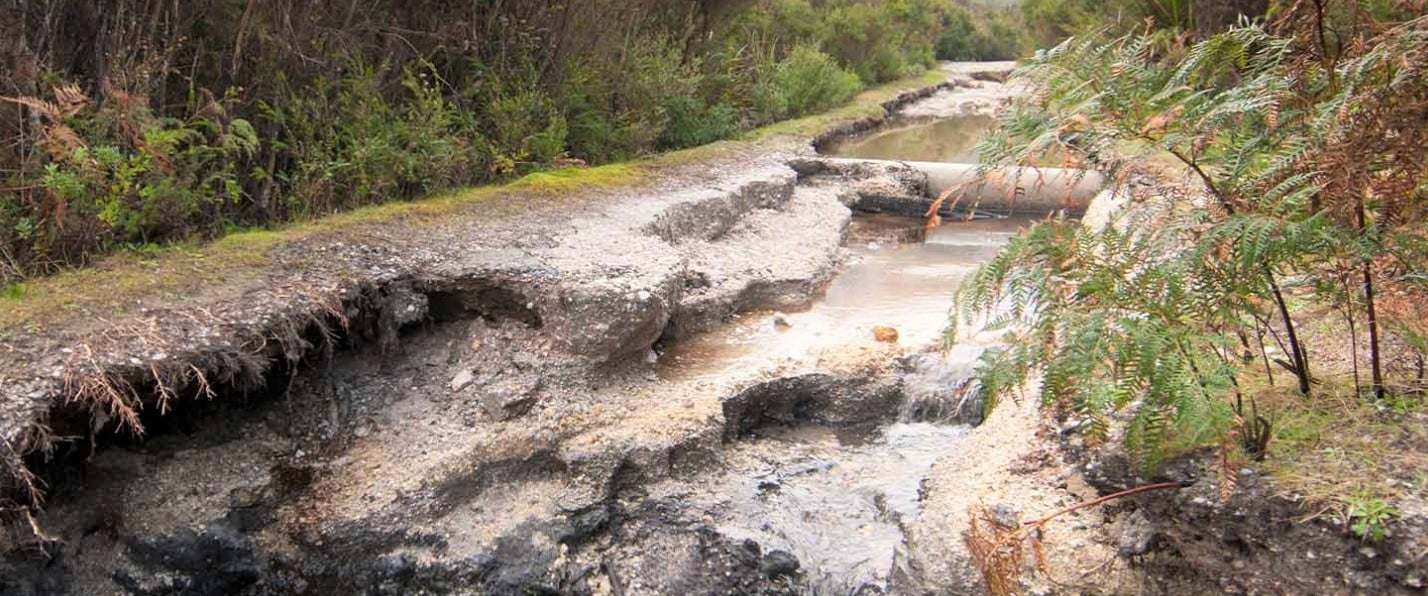
Following heavy rainfall and flooding in East Gippsland and severe weather in other areas, several National, State and Coastal Parks sustained significant damage. Some parks, facilities and tracks are partially or fully closed.
This includes areas of Croajingolong NP, Cape Conran Coastal Park, Mitchell River NP and Snowy River NP. Parks Victoria staff continue to assess and repair sites so that they can be safely opened to the public.
Don’t waste your trip: check the Parks Victoria website before you head off for a walk, exploration or school holiday camping trip.
The alpine environment is perfect for adventurous and exciting winter activities, including bushwalking. Here are three websites designed to help you to stay informed, prepared and safe.
Snowfalls have been recorded at quite low altitudes this season. Public huts can provide much-needed shelter, so it’s timely to check out the Victorian High Country Huts Association Hut Code.
The Mountain Safety Collective provides daily observations and forecasts of likely alpine hazards in Victoria and New South Wales, right through the snow season. Check their Backcountry Conditions Reports on their website.
The revamped SnowSafe website provides essential information on how to enjoy the alpine environment in safety and comfort; planning and preparation are highlighted.
The Australian Ski Patrol Association (ASPA) has launched its revamped SnowSafe website to help you be aware of the dangers of the alpine environment. Make sure YOU can enjoy this wonderful part of our country in safety and comfort.
Whether leading a club walk or enjoying a day on the track with friends, bushwalkers need accurate maps. The popular resource Finding Maps for Bushwalking in Victoriahas just been revised and updated. It provides comprehensive information on sourcing quality, up-to-date paper and digital maps – invaluable for walk planning and safe navigation out on the track.
Grampians Peaks Trail Maps
After opening late last year, the 164km Grampians Peaks Trail has proved immensely popular. Walkers will find these excellent Parks Victoria maps invaluable. Each map (at a scale of 1:50:000) covers one area – Northern, Central or Southern – and includes an altitude profile, section summaries, track notes and useful information on planning, trail access, hike-in campgrounds and emergency information.
After being unavailable for several months, the maps are now back in stock at specialist map suppliers, some outdoor shops and several suppliers in the Grampians/Gariwerd region.
It’s important to note that some experienced bushwalkers report that the suggested daily walking times are appreciably understated. In addition, each day’s walk duration and distance excludes all side trips, many of which – such as the ascent of Briggs Bluff and Mt Difficult – are immensely rewarding, but can add up to 2 hours to your day.
Staying dry and warm on a winter bushwalk can be challenging. Here are some seasonal reminders to make sure that you’re equipped with the right clothing, gear, food and knowledge to help you deal with whatever the weather throws at you.
Carry and wear suitable clothing to protect yourself from cold temperatures, particularly when combined with rain and wind.
Use layering under waterproof gear, but avoid wearing too many clothes, or you may become wet from perspiration and condensation.
Ensure a regular intake of high-calorie food and drink. Do not drink alcohol, which accelerates heat loss.
On overnight walks, be self-sufficient: you should not rely on reaching mountain huts for shelter.
Prevent physical exhaustion: walk within your party’s capabilities.
Know how to recognise and treat hypothermia. Be aware of its early signs; take into account that long stops, or immobilisation due to injury, increase susceptibility.
Take particular care when walking with more susceptible people, such as young children, slightly-built or less fit individuals.
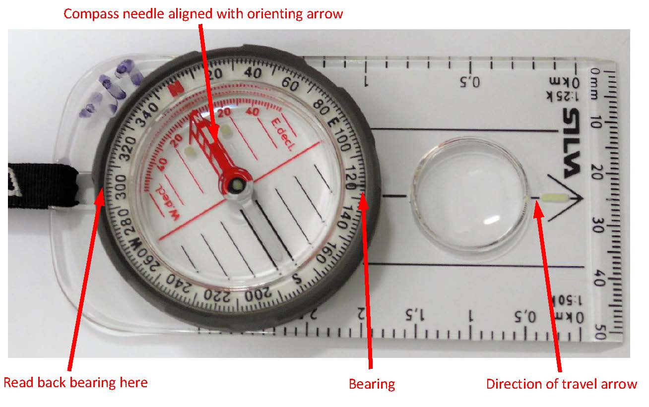
A back bearing is exactly the opposite direction to the direction of travel arrow on your compass i.e. it’s 180 degrees’ difference. If you’re navigating with map and compass alone, simple back bearings can be extremely useful. Here are three situations when they come in handy. Check out the diagram, then add back bearings to your navigation ‘tool box’.
Increasing numbers of bushwalking maps are now available in electronic form alone, with paper versions becoming more scarce. For convenience and safety, many walkers still prefer to carry both printed and electronic maps. Fortunately, it’s relatively easy to print to scale from an electronic map. Here’s how to print a geopdf map – either a whole map or part thereof.
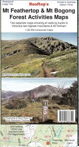
Rooftop Maps has recently released a new Mt Bogong map which is suitable for serious walkers who wish to explore Victoria’s highest mountain. The track notations are particularly useful. Here’s a short map review.
The recently released Dandenong Ranges & Lysterfield Hills Map Guide 1st Edition by Meridian Maps– the first comprehensive map to cover both of these areas – is now available in both printed and electronic versions. It’s the ideal walking companion, featuring 32 day walks ranging from 1km to 16km, along with details of the 72km multiday Dandenong Ranges Trail. There’s also information on mountain bike trails and all the region’s attractions.
The increasing popularity of smartphones and handheld GPS devices leads to the question: ‘Are traditional map and compass skills relevant any longer’? Whilst the reassuring blue dot on a digital map tells you exactly where you are, there’s immense satisfaction in developing bush navigation skills and knowing how to use a compass and topographic map. As technology can’t be relied on 100%, these skills are particularly important on longer trips; they can also be used when taking part in other outdoor activities.
Whether you’re new to navigation and would like some introductory information, or if you want to brush up on how to read a map, use a compass, or hone a specific navigation technique, CLICK HERE for a comprehensive list of resources. The short video clips are particularly useful. With these skills (as Australia’s late pioneering bushwalker Paddy Pallin said) you’ll be “Never Truly Lost”.
Stay up-to-date with the latest Bushwalking News
Recieve the very latest Bushwalking News by entering your details below...