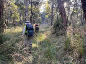
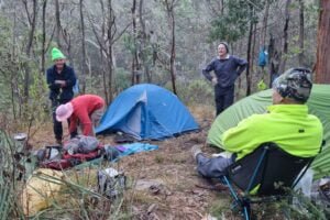
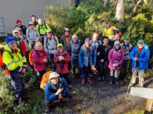
On Friday afternoon nine hearty volunteers (including 3 from BCWC and 3 named Peter) met up with Daniel Ball, Forest Management and Roading Officer, at the DEECA Depot in Dargo for a welcome and briefing in preparation for their work on the Crooked River section of the McMillans Walking Track. It was anticipated that this would be a challenging weekend of track clearing because of its remoteness, difficult access and unknown condition; and so it proved to be. Capable 4WD vehicles were required to get to either end of the 13km section of the track. All camping gear, supplies and work equipment had to be portaged 4km up the track to a make shift camp. There are no recognised camping sites along this section of the track, it took some effort and ingenuity to find and make a camp site not too far from water, tents were strung out along the track. Participants were instructed to “Pack light and compact in a back pack; a small tent, dare I say dehydrated food, limited luxuries. Be self sufficient for camping and all meals except the Friday BBQ”.
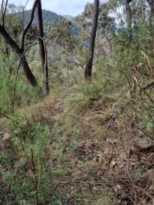
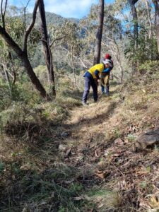
The team was pleasantly surprised to find that the first 4km up from the Stonewall end was easy walking having been cleared in recent times, as was the first kilometre and a half from the other end off White Timber Spur Track. Over the weekend the team chain sawed the logs off the whole length of the track leaving some easy-step-over ones and thoroughly cleared a bit over 3km including some dense patches of blackberry. They also did some step cutting and track benching to make walking easier. There is still some 4.5km of track that needs further work in the near future. Blackberry is an issue, it is in patches over the whole length of the track. Spraying would be desirable.
Fine weather blessed the team for the whole of the duration and they enjoyed being on this historically significant track constructed by gold miners in the 1860s through the stunning scenic steep sided Crooked River valley. The benched track was constructed, at places high above the river, to a high standard with dry stone walling still in good condition in some sections.
The volunteers contributed a total of 336, otherwise payable, hours to this activity.
Thank you to Daniel and DEECA for their contributions and support; the BBQ goodies, which were enjoyed on Friday night at Bulltown and on the track for lunch on Saturday, the use of trunk radios and access to their depot at Dargo for getting organised and parking cars and the BTAC trailer over the weekend. And thank you to the volunteers for their time, effort, achievement and camaraderie over the ANZAC weekend on the Crooked River section of McMillans Walking Track.
Cold and damp conditions greeted 26 volunteers from Bushwalking Victoria’s Bushwalking Tracks and Conservation group (BTAC) and members of the Friends of Baw Baw National Park (FoBB) as they carried out maintenance activities on walking tracks in the park. This joint activity has become a regular and popular event on the BTAC and FoBB calendars. This year’s event was even more popular than ever, despite the conditions, as volunteers had free access to extremely comfortable lodge accommodation for the duration of the event; this was provided by the Mount Baw Baw Alpine Resort. A further carrot was provided by Parks Victoria who sponsored the event dinner on Saturday night. Thank you to these generous supporters.
With an enthusiastic and hardy group we were able to achieve significant track clearing progress along the Tanjil Link Track to Phillack Saddle and then in both a north and south direction along the Australian Alps Walking Track (AAWT).
Key achievements:
26 volunteers joined the activity.
4,000 meters of track cleared from the National Park boundary with the Alpine Resort in a northerly direction, this includes all the Tanjil Link Track.
3,000 meters of track cleared from Phillack Saddle in a southerly direction towards Mount Erica.
15,000 meters of track from the Alpine Resort boundary towards Stronach’s Camp was cleared of fallen logs.
Two boardwalks on the Tanjil Link Track were repaired.
19 water bars and drains were cleared.
749 volunteer hours contributed.
Including 49 hours of event management and 172 hours of volunteer travel time.
Two AAWT end to end walkers, who decided to break from the hike for a few days while the weather improved, decided to join our group for two days. We were very appreciative of the energy of these young volunteers.
The event attracted four first time volunteers and we welcomed back two volunteers who we had not seen for a number of years. The remainder of our volunteers are the group of diehards we unflatteringly call the “repeat offenders”.
Sunny Sunday’s picture:
In addition to providing lodge accommodation the Mount Baw Baw Alpine Resort provided the services of two of their employees and an ATV to transport our equipment to the work site on Thursday afternoon and return it to the Resort on Sunday night. Thanks to James and John.
Weather Conditions for the Event
Just in case you want to know how hardy our volunteers are, check out the temperatures over the 3 day volunteering event. While Friday and Saturday were cold and wet we were lucky that the vast majority of the rainfall occurred at night when we were tucked up warm inside the lodge.
A PLB (Personal Locator Beacon) should only be activated in a situation of grave and imminent danger; a life threatening situation. (The Bushwalking Manual, Bushwalking Victoria Inc.)
Sensible advice indeed but where the line in the sand is for this decision is a little subjective. There have been instances where people have become disorientated or caught out after dark, thought the situation as dangerous and have set off their PLB. Perhaps inconvenience more than imminent danger was the reality. Maybe a sense of panic or just inexperience that made them reach such a decision. There is the other end of the scale when pushing on further into a deteriorating situation, or not understanding the seriousness of an illness or injury, could complicate a rescue or possibly lead to a fatality due to a delay to seek help. Finding that unsweet spot is the challenge.
I reached a decision to activate my Garmin InReach SOS (similar to a PLB with additional satellite text message and GPS) on a solo journey on the Australian Alps Walking Track in late 2022. This played out on the Long Spur between Mount Bogong and Mount Wills. The night before saw a cold front with gale force winds roar through Camp Valley near Cleve Cole Hut. It was an uncomfortable night in my tent with only an hour or two of sleep. The morning wasn’t much better with only a slight easing of the wind, with rain and sleet still blowing through. I toyed with the idea of staying another day and sitting out the weather in Cleve Cole Hut, or would I plug onto Mount Wills, my next rest day with a food drop including a few little luxuries and a hut for shelter, if needed.
Mount Wills won which would turn out to be a better decision for other reasons than food drop goodies. I donned full wet weather attire and headed over Bossiaea Hill and onto the Long Spur which had just been cleared by Bushwalking Victoria’s BTAC volunteers the week before. Not far into the Long Spur, I noticed a mild twinge around my right lower back and put it down to an uncomfortable night’s sleep. Within an hour it had become an excruciating pain around my kidney area, sending waves of pain through my body with hot and cold sweats, and vomiting. I knew it was likely kidney stones, something I had experienced nearly 30 years earlier and had discussed with my GP in my pre-trip planning. The chances of it happening again after so long were slim. My GP did prepare me with strong pain relief tablets for other injuries, me not thinking I would need them for kidney stones. I took one and the pain eased almost immediately. I decided that with a cleared track, and if I could maintain the pain at this level, I would try for Big River Saddle. A rescue was going to be easier from a 4WD track or road. Air rescue would have been impossible in such weather and stuck high on the foot track would have required a complicated stretcher carry.
With this small window I made haste along the BTAC branded track! An hour later the pain returned like a hammer blow. I took a second tablet which did little. I doggedly pressed on and eventually got onto the 4WD track that would lead me to Big River Saddle. Things weren’t good, I was becoming weaker and sicker, and my mind was far from rational from the pain and possibly the tablets.
Somehow, I managed to keep to my objective and knew I would activate the Garmin SOS at Big River Saddle. On arrival I struggled a sadly pitched tent and took shelter. By now the pain relief tablets had totally worn off and I was afraid to take more, I just felt too weak and would have been well over the prescribed dosage. I tried changing into dry clothes, but couldn’t as my body was shaking with some sort of shock reaction. I wrapped my sleeping bag around me as best as I could and got on with the Garmin which I hadn’t used much, certainly not for a rescue. I did take time to check the battery at Mount Hotham and studied up well on how to use the SOS function at home.
I’m a little vague on the sequence of how it all worked out. I just pushed the SOS button hoping help would come and I think I got a message back almost immediately asking me to confirm an emergency. I also got a phone call from a US number to my mobile which I couldn’t talk to because of weak mobile reception. This was followed by further messages on the Garmin asking me if I had shelter, was it a medical rescue or other, did I have supplies. I’d forgotten there are pre-set messages you can use to reply YES NO etc, and I found it hard using the clunky arrow type keyboard screen. Eventually all were answered, and a message was received back saying that Garmin had successfully notified local Australian emergency services of my situation, the location and that a rescue was being arranged. Garmin works outside of the Australian PLB network which is coordinated through an organisation in Canberra. Garmin has its own centre in Texas.
Coming down the Long Spur I felt nervous about this and had silly thoughts about US time differences etc, what if they all go home at 5.00 or it all just goes wrong for some reason.
My rescue was coordinated by the Tallangatta Police. Two and a half hours later I sensed someone shaking my tent and a voice outside asking loudly, “is Owen Morris in there”. During the wait time I may have been lulling in and out of consciousness, as it seemed only moments before I had been fiddling with the Garmin. When the tent door unzipped, I was just so relieved to see the beaming faces of the paramedic ambulance crew from Omeo. They kept me lying still in the tent and checked all my vital medical functions through their portable monitor, then put me on a stretcher and into the 4WD ambulance. They also kindly packed up my mess. The paramedic ambulance officer administered a drip with some difficulty, he said it was difficult locating an open vein and apologized for treating me like a pin cushion. A small dose of Morphine was given and the next thing I remember was arriving at Omeo hospital. Two wonderful nurses there liaised with Bairnsdale Hospital doctors for my treatment because there was no doctor at Omeo Hospital that evening. More pain relief, more weird sleep of a kind! At 2 am I was woken by the night shift nurse and told I was going on another ambulance ride to the larger Bairnsdale Hospital, as she was a little concerned I wasn’t stable in a couple of areas. I certainly felt very weak. I recall the next morning having blood tests and a MRI scan. Later that afternoon the Doctor told me I had passed the kidney stone and things were stable enough for me to leave, but I shouldn’t return to my hike!!! I gladly took the train back to Melbourne.
Some Take Outs: Good planning, adequate remote hiking experience, having a PLB device and understanding how and when to best use it. The importance of reasonably clear tracks. If the track had been overgrown and with fallen timber like some parts of the AAWT I wouldn’t have had a hope of reaching the 4WD track or Big River Saddle and the rescue would’ve been more complicated to stage and slower.
Me? It certainly was an ordeal, I had nightmares after it and initially found it difficult to talk about without getting emotional. I’m OK now, probably talk about it too much, but best not to overthink it too much. I still go to the mountains. Perhaps I’m a little apprehensive about extended hikes and remote areas now. No photos, but a selfie painting with a bit of Long Spur chaotic artistic license, except the flesh tone! That’s close…
Finally. We live in a country with police, paramedics, nurses, and doctors who for the most go about their work to such a high professional standard and with spades of compassion. To execute a rescue within two and a half hours is quite remarkable. My family and I are so grateful for the rescue and everyone’s care of me, along with the time taken to update my loved ones with a calming reassurance that I was safe and in good care. I certainly was.
Owen Morris
BTAC Volunteer and Strzelecki Bushwalking Club Member
The Tasmanian Parks and Wildlife Service has advised that the Walls of Jerusalem National Park and the western section of the Central Plateau Conservation Area will be closed for all of May 2023 and 2024 while aerial shooting operations are undertaken.
While May is not prime walking weather some people prefer the quietness of the Tasmanian shoulder season. To avoid disappointment make sure you check out the website before planning your Tasmanian walks.
Notorious No More!
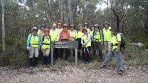
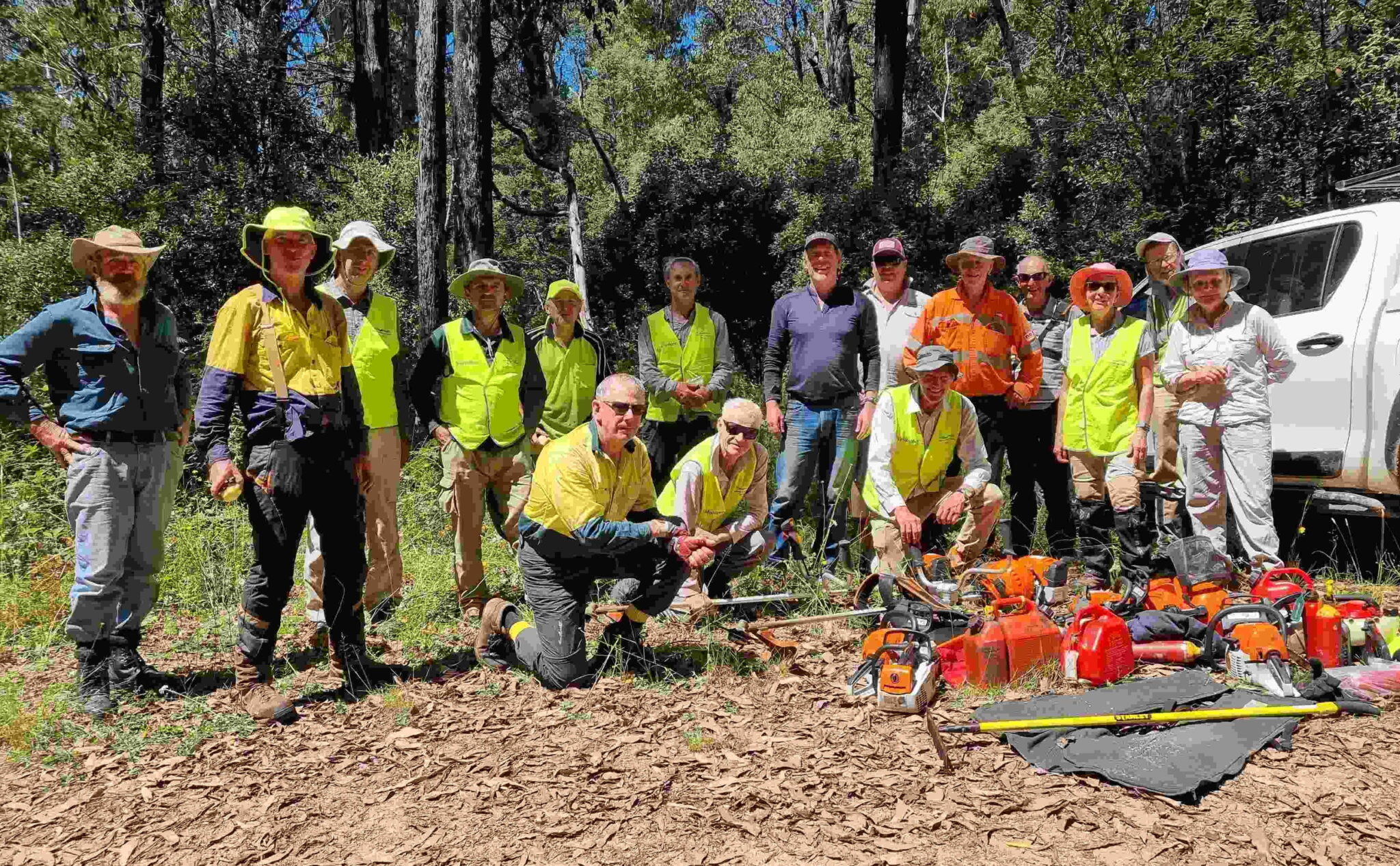
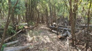
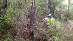
The BTAC February track clearing event involved clearing a section of the Australian Alpine Walking Track from Mt Sunday to Low Saddle in the northern extension of the Mt Skene Natural Features and Scenic Reserve. This relatively small section of track is only 3 kms but has had a reputation for being very challenging due to the large amount of fallen trees and growth that made the route indistinct.
Twenty keen volunteers fronted at the 7.30am safety briefing at the Mt Sunday helipad on Saturday morning. This in itself was no small task with many poor sections on the access roads due to rain damage, a tree down at Low Saddle (which Parks Vic cleared as cars waited to get through) and a steep 4WD climb to the helipad campsite. Thanks to the number of chainsaw operators that volunteered and their experience we made good progress into the fallen timber and reached Low Saddle by early afternoon on Sunday. This was well beyond expectations and a credit to the team work and great effort of the volunteers.
For a rather exposed mountain top, the weather was pleasant on the Mt Sunday helipad which allowed good community social time under the alpine stars with the lights of Buller in the distance. Thanks to Jim Craven, Parks Vic who dropped off gear and supplies for the BBQ and the volunteers who helped in the preparation and cooking.
Below images show Before and After shots!
I would like to thank all the volunteers who worked so hard and supported each other so well to get the job done. The posting on the BTAC Facebook page received some great comments that show the appreciation of the walking community:
“Big, big effort and thanks. That section was a commando training course before this. Amazed you have been able to clear it so quickly. Lots of hard work”.
“Wow, legends! any FKT attempt just got 3h faster”
“Makes you want to go back and do it again knowing where the track is this time”
“Thanks for the great work! It’s a small part of the track with a notorious reputation. I’m sure those that pass through will appreciate your efforts.”
On 31st January 2023, West Gippsland Bush Walkers Inc celebrated 25 years of its incorporation. The celebration, which was held at Mt Worth Moonlight Picnic Ground, was attended by over 70 people including current and former Club members, representatives of Baw Baw Shire, Friends of Mt Worth, Parks Victoria and Warragul and Drouin Gazette. One of the highlights of the event were presentations of two long standing members who reminisced on the Club beginnings. The formal part of the celebration was followed by sharing of a designer cake decorated with the Club logo.
West Gippsland Bush Walkers Inc was formed on 10th February 1998 after an adult education organization, Warragul Proceed, was disbanded. The members of the informal group decided to continue walks as part of an autonomous organization affiliated with the Victorian Federation of Bush Walking Clubs. Some of the original members of the Proceed group still remain as active members today. The Club uses the same logo that was designed 25 years ago “ADVENTURE, FRIENDSHIP, FITNESS” which perfectly describes the spirit of the organisation.
Every fortnight West Gippsland Bush Walkers Club offers three levels of walks with about 45 members attending. The Ramblers generally walk 7 to 10 kilometres on well-formed tracks at a slower pace than the other two groups. The Hikers walk 10 to 14 kilometres at a faster pace, usually on more challenging terrain than the Ramblers. The Trekkers generally walk 15 to 20 kilometres and engage in more challenging walks, with steeper terrain and elevation changes of up to 600 metres.
Apart from regular walks, every year Club members organise two weeks away, a bus trip, a Club BBQ and Christmas dinner. Past locations of weeks away have included Mornington Peninsula, Apollo Bay, Mallacoota, Jindabyne and New Plymouth in New Zealand.
Some of the significant Club achievements include receiving, in 2019, the Victorian Senior of the Year Award in the Age Friendly Victorian Award category, as well as securing several government grants to help fund its activities.
The Club co-operates with Friends of Mt Worth, Parks Victoria and DEECA, and takes part in clearing and maintenance works at Mt Worth and Bunyip State Parks.
More information about West Gippsland Bush Walkers Inc activities can be obtained through the Club website https://wgbwc.clubexpress.com/
Parks Victoria will engage the services of a contractor to undertake deer control in the Baw Baw National Park on 5-11 March 2023, dependent on weather conditions. The above map shows the area in which deer control will occur.
The park will not be closed when deer control work is being undertaken. Signs will be placed at major access points advising visitors that deer control is being undertaken. All personnel involved will be working under the supervision of Parks Victoria staff. They will be readily identifiable and will act in accordance with all legal requirements to ensure the safe use of firearms. Over the past decade there has been a significant expansion of deer across Victoria and of particular concern is the increasing deer activity at higher elevations. Baw Baw National Park is home to high quality, relatively intact, alpine peatlands and deer presence has a significant impact on the resilience of alpine peatlands.
Alpine Peatlands and Associated Fens are an endangered ecological community listed under national and state legislation (the Commonwealth Environmental Protection and Biodiversity Conservation Act (1999) and Victorian Flora and Fauna Guarantee Act (1988)). They provide a critical hydrological function at the top of the water catchment, filtering water and modulating flows. Alpine peatlands also provide habitat for several threatened species including the alpine water skink, alpine she oak skink and Baw Baw frog.
Deer pose the greatest threat to alpine peatlands by trampling, wallowing, grazing and thrashing their antlers to remove vegetation. A recent study by Davies et al. 2020 used a camera array to confirm anecdotal information that Sambar deer are present in Baw Baw National Park.
The Alpine National Park Deer Control Trial (which concluded in 2020) has shown ground shooting using contractors is an efficient and effective approach for controlling deer in the alpine environment. Parks Victoria takes coordinated action, informed by scientific research, tailored to individual parks and target species, to reduce the damage caused by deer and feral animals. Each conservation program is one of hundreds of programs across Victoria using available tools to protect nature.
Please contact Parks Victoria if you have any questions or would like more information on this project at conservation@parks.vic.gov.au, or call 13 1963
Parks Victoria is responsible for conservation management to restore and protect park habitat, including the control of introduced plant and animal species. Following the 2019 bushfires affecting Bunyip State Park, Parks Victoria has observed large numbers of deer within the park. While over 500 deer were removed by professional contractors between July 2020 and December 2021, deer are still relatively abundant. This has also been confirmed by reports from the local community.
Control of deer is required within key areas of the park for the protection of waterway catchments along the Diamond and Cannibal Creeks, the Diamond Creek Reference Area and along the Bunyip River aqueduct. With the program’s extension to the north and east of previous control works, the impact of deer on threatened flora and communities will be further reduced across the park footprint.
Parks Victoria will be undertaking a controlled, safe and humane deer control operation targeting Fallow and Sambar Deer using ground shooting within Bunyip State Park and Kurth Kiln Regional Park (see map of control areas attached). The program will:
Reduce habitat structure damage and minimise browsing impacts on habitat regeneration following bushfire.
Focus on movement corridors that aim to reduce the impact of deer grazing on surrounding private land.
The program will operate between the November 2022 and June 2023 using accredited and authorised ground shooting contractors. Safety is of utmost importance to Parks Victoria and the program will follow strict safety protocols. Signs will be displayed at all official entrance points to the control zones during the control operation.
Refer above for location map of area subject to deer control
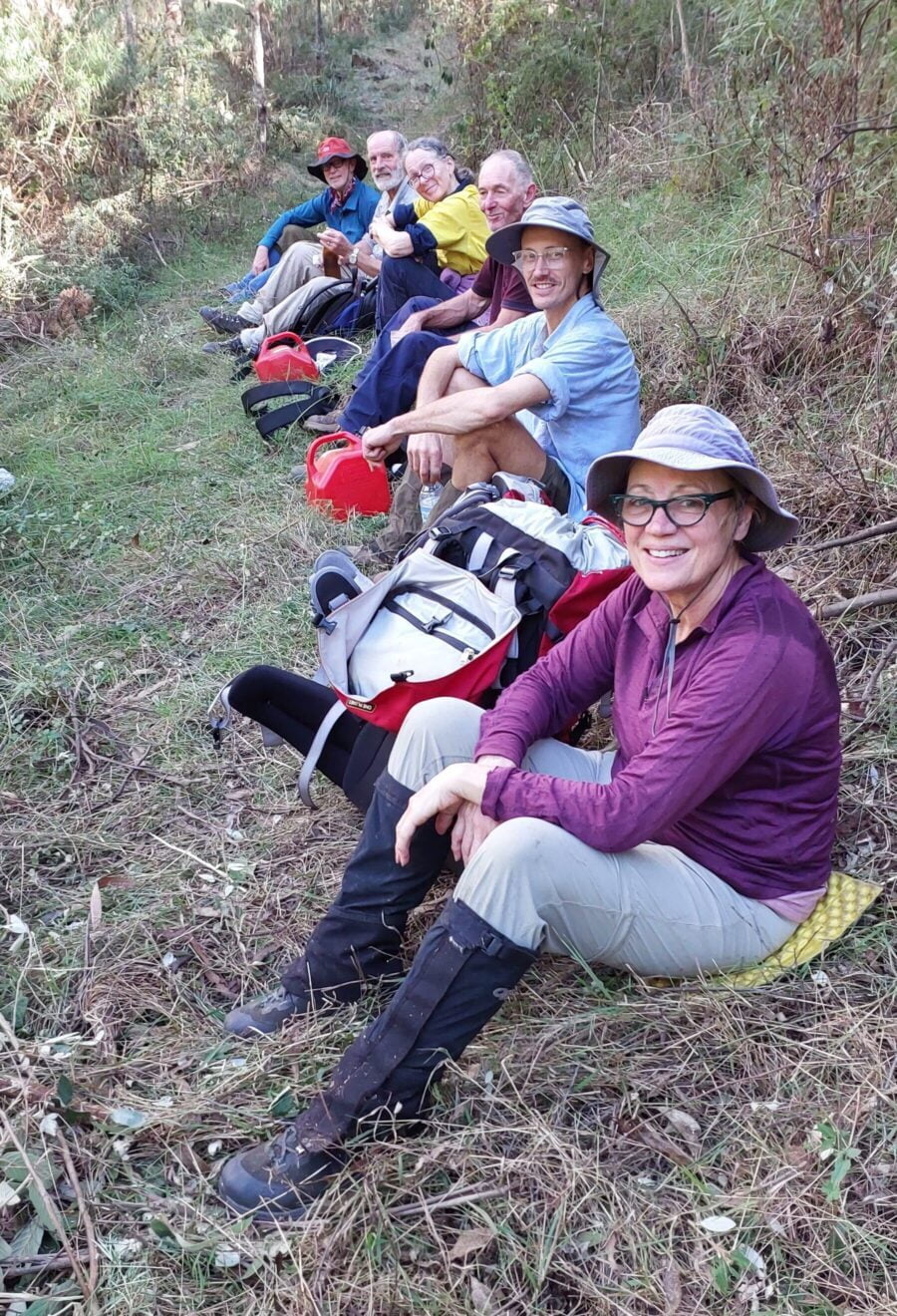
Fourteen BTAC volunteers worked with Parks Victoria to improve walking access to Tali Karng from the Tamboritha Road in January 2023. They made improvements to the many river crossings on the Wellington River to make navigation easier, cleared overhanging vegetation and did some work on the Riggall Spur Track, but the main emphasis was clearing the overgrown 6.5 km Clive Lanigan Memorial Track through the Valley of Destruction terminating at Tali Karng. It wasn’t all hard work, there was great camaraderie at the camp and volunteers were entertained by the antics of a small black platypus in the Wellington River adjacent to the camp site.
This was a logistically challenging activity with weather and access tracks needing to be dry for the activity to go ahead. It was clear a few days out that the conditions were favourable and that the contingency work would have to wait for another day. The volunteers gathered at Muttonwood Camp on the Wellington River north of Licola on Australia Day ready for an early start next morning to get to and establish camp at the base of Riggall Spur Track, 13km upstream from Tamboritha Road.
On the Friday morning participants parked their vehicles at the Platypus Camp and walked with day packs up the Wellington River, attending to river crossing improvements with hand tools, to the camp site. All camping gear, supplies for the weekend, tools, equipment and PPE were transported to the camp site by two Parks Victoria vehicles which negotiated a network of 4WD tracks, including Management Vehicles Only tracks, to get to the camping spot. A few volunteers scored a ride on the vehicles. Brush cutters were used to clear sufficient area for all the tents and amenities.
Saturday’s forecast was for temperatures into the 30’s so it was an early 7:00am start and an early finish for the two work teams. All workers were back in camp by 2:30pm to make full use of the river and shade to keep cool. It was during the afternoon that Meredith sighted the little platypus as it made its way upstream time and time again, sometimes leaving the water, just to be swept downstream by the current again to a pool created by a log across the river. Parks Victoria rangers provided the volunteers with a sumptuous BBQ for the evening meal.
Sunday and Monday were long days as each day the walk to the start of work and return from knock off position was longer. Fortunately these days were cooler, but still a bit humid. It was heavy work to clear the track of vegetation and fallen logs among all the rocks. The lake, Tali Karng, was reached around 2:30pm on Monday, mission achieved. That night the volunteers slept well with the satisfaction of a job well done.
On Tuesday the camp was packed up and everything stowed on the Parks Victoria vehicles for the journey back to the cars at Platypus Camp. The majority of the volunteers walked the full distance back to the cars with some still having enough energy to do some track clearing with hand tools along the way. The team contributed some 650 volunteer hours to achieve the objective.
Many thanks to the Parks Victoria Rangers, Tehan, Bek and Sam for their hospitality, facilitation and support. Thanks to Patrick for leading the second team and thanks to all the participants for their dedication to the task and their camaraderie throughout the six days.
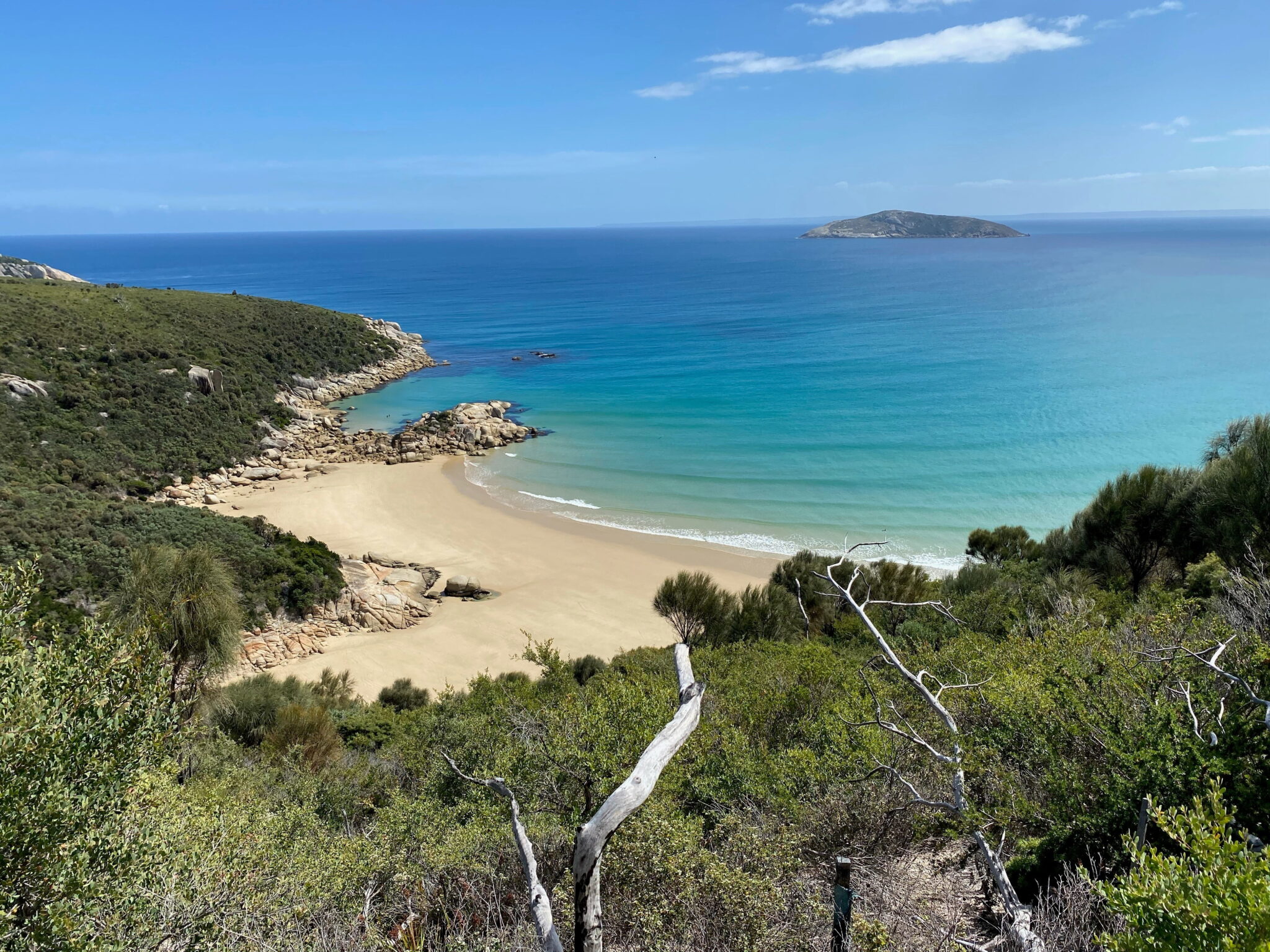
The Victorian Government is investing $23M to revitalise Wilsons Promontory NP. It will become Victoria’s largest conservation sanctuary and have improved visitor experiences.
The current proposed scope for the Wilsons Prom Revitalisation includes:
an exclusion fence across the Yanakie Isthmus – together with conservation programs, the fence is designed to stop destructive introduced species, helping make the national park a sanctuary where native animals and plants can thrive
an upgrade of the visitor area at Tidal River with improved toilets, seats, shelter and a renewed visitor centre
additional cabin-style accommodation outside the northern park boundary, and at Tidal River
upgrades to the Wildlife Walk to make it all-abilities accessible
a new Telegraph Saddle trail to connect Tidal River and Mt Oberon.
Parks Victoria is doing feasibility studies, assessments and talking to the community about their ideas and preferences. The draft designs for the visitor area at Tidal River are now available and open for public comment.


 This was a logistically challenging activity with weather and access tracks needing to be dry for the activity to go ahead. It was clear a few days out that the conditions were favourable and that the contingency work would have to wait for another day. The volunteers gathered at Muttonwood Camp on the Wellington River north of Licola on Australia Day ready for an early start next morning to get to and establish camp at the base of Riggall Spur Track, 13km upstream from Tamboritha Road.
 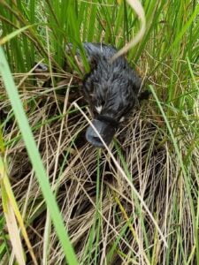 On the Friday morning participants parked their vehicles at the Platypus Camp and walked with day packs up the Wellington River, attending to river crossing improvements with hand tools, to the camp site. All camping gear, supplies for the weekend, tools, equipment and PPE were transported to the camp site by two Parks Victoria vehicles which negotiated a network of 4WD tracks, including Management Vehicles Only tracks, to get to the camping spot. A few volunteers scored a ride on the vehicles. Brush cutters were used to clear sufficient area for all the tents a