Great Walks editor Brent McKean, describes going on a pilgrimage, even though that was never the plan.
“I’ve never walked an official Camino but I ended up having a pilgrimage without knowing it.
When I was 28 my best mate died of cancer. Robbie was a year older than me and we had been through a lot together. We travelled through Europe in a kombi van, partied in London and spent a bunch of summers on the Gold Coast. First we were travel buddies, then we were flatmates, then best friends. Read More HERE
A Cautionary Tale: 3rd May, Caravan Park, Portland. Having got Footnotes published last night I looked forward to walking with Jan Shaddick at the start of the GSWW section from Battersby Camp to North Nelson Road. I had dropped Brian who was driving the bus, and the 3 other members off at Battersby Camp to catch up with the rest of the walkers, and Jan S and myself walked out behind them for 3 km before turning back. Last night was blowing a gale, pouring rain, and we had woken up to similar this morning, with 90km winds forecast for the day. On the drive out to Battersby we had driven through a very strong downpour, with strong winds, but it was fine when we got out to the camp. Walking along the river the sun came out, and we only had a couple of light showers.
There had been a school group from Warrnambool camped there, but they were packing up to leave as we started our walk, and a truck was waiting to pump out the toilet (which had been done by the time we got back from our walk). On arriving back at the camp I took the advantage of going to the toilet rather than finding a tree, but as I was leaning over to close the lid, my elbow caught my mobile phone sticking out of my shallow raincoat pocket, and it flew across in front of me, down the toilet. Being a drop-down toilet over a vertical pipe, using a torch one could just see the phone case lying at the bottom. Luckily, since the toilet had been pumped out only an hour before, there was only a thin sludge at the bottom, but it was at least 10 or 12 ft down a narrow pipe. I was in despair. Couldn’t believe what had just happened! The end of the world! Not only the loss of my phone, but also my bank cards which I carry in the phone case. Sheepishly I informed Jan of my dilemma, and we racked our brains as to what we could do. Was there any possibility of ringing Parks Victoria and asking if there was any chance I could retrieve the phone when they next pumped out the toilet, since we were staying here another week? Slim chance of that happening, but I was clutching at straws. Just then 2 park rangers drove past (Tom and “Shorty’ from the Nelson Depot), checking for fallen trees and branches following the severe storm overnight. Jan flagged them down and explained my predicament.
After Tom had a dig at me as to ‘why I was playing on my phone while on the toilet’ they spent the next hour trying to work out if and how they could retrieve the phone. First they brought out a very long shovel, but that only went about halfway down, so they added a loose broom handle which they duct- taped to the shovel – but that still didn’t get down far enough. Then they unscrewed the plastic head of a garden rake off the pole and taped that to the other two, which got them to the bottom.My ‘knight in shining armour’ Tom had me holding his phone torch (with the strict instruction not to drop that one too) and he spent about 15 minutes trying to drag the phone up the side of the pipe, but unfortunately there was a lip on the side of the pipe which he couldn’t get past without the phone dropping off the shovel. So they decided to go back to their depot in Nelson to get something better to get under the phone and lift it up. In the meantime Jan and I were stopping a school group that we had met on the track from using that toilet (I had used the disabled toilet, so there was still a regular toilet on the other side available for use). After they had left, a horde of Year 9 students from Beaconsfield arrived on trail bikes, so after explaining our predicament (further embarrassment) we had to block them from using the toilet too. Then our Park Rangers returned, with an excellent tool that would fit under the phone and bring it up. Unfortunately that proved too wide to go down the toilet. They did everything they could to bend the tongs of the tool and bashed it with a hammer, but got nowhere. So that idea went down the toilet (excuse the pun, and anyway it wouldn’t go down the toilet!) Then with lateral thinking they had 2 small L shaped brackets which they taped to a short piece of dowel, then taped that securely to the multipiece-pole still sitting in the toilet. They removed the shovel at the bottom of the multipiece ‘pole’ and by stretching down (and by this time his mate was holding the torch, since I couldn’t blame him for not trusting me!)
Tom successfully brought up the phone. Hallelujah!! There was a tap nearby so I was able to sluice off most of the faeces, and put it in a plastic bag. It was still working! I asked the rangers to have a drink at the pub on me for their wonderful efforts, but they wouldn’t accept any payment.
Back at the caravan park I thoroughly washed the phone, my two credit cards, and a $5 note in hot soapy water, and threw the suede phone case in the rubbish bin. While generally appearing to work, pushing buttons didn’t get results, but after removing the clear plastic sheet which protected the screen, the phone worked perfectly. Of course, at happy hour that night, Jan stole the show recounting our events of the day, and for the next 24 hours it was the main topic of conversation (and regrettably might be the most remembered part of the basecamp).
Jan sent an email to Parks Victoria thanking and commending Tom and Shorty – ‘On a busy day for them, they took time to assist us, and we are very grateful. Please thank them again and congratulate them on their willingness to help’.
Neil Bellamy is a man on a mission: to bring in mandatory safety standards for rain jackets. His campaign began after he observed poorly-equipped hikers on the Overland Track and heard about a walker who nearly died of hypothermia. That walker had purchased a jacket that was marketed as ‘waterproof, windproof and breathable’, but which turned out to be totally inadequate for alpine conditions.
Choosing a rain jacket that’s fit for purpose can be difficult – many outdoor shops carry a broad range of casual wear and travel wear, as well as clothing suitable for activities such as skiing and bushwalking. Sales staff don’t always have sufficient knowledge to help customers identify the right gear for their specific needs.
In April last year, we published an article titled ‘Staying Dry – Waterproof and breathability ratings explained’. Here’s an excerpt:
Keeping dry and comfortable is a balance between allowing perspiration to escape, and keeping moisture out. Waterproof ratings and breathability are key. But what do these terms mean? What’s the difference between ‘water resistant’ and ‘waterproof’? How should the rating numbers be interpreted? Before you head off to your favourite outdoor supplier to purchase a new jacket or overpants, here’s a useful link which will answer many of your questions – or tell you which questions to ask!
Bushwalking Victoria supports Neil’s submission to the Australian Competition and Consumer Commission to introduce mandatory safety standards for rain jackets. We’ll keep you informed about his campaign. In the meantime, in the absence of trustworthy garment tags stating “This garment is licensed for use in alpine conditions” or similar, here are some golden garment rules for winter conditions:
Be properly informed about the terrain and weather conditions you may encounter.
Purchase specialty bushwalking gear that’s fit for purpose from a specialty shop with informed staff.
Buy a jacket with a minimum waterproof rating of 20,000mm and breathability of 20,000g/m²/24 hours.
Out on the track, stay dry: water conducts heat nearly 30 times faster than air.
Hypothermia is deadly. Your rain jacket is a crucial safety item. Choose well!
Winter is around the corner and many people think that there could be few experiences less enticing than camping in the snow. However, snow walking, snow shoeing, ski touring, backcountry snowboarding and snow camping are popular among outdoor enthusiasts.
Notorious No More!
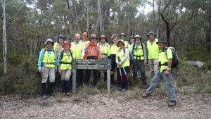
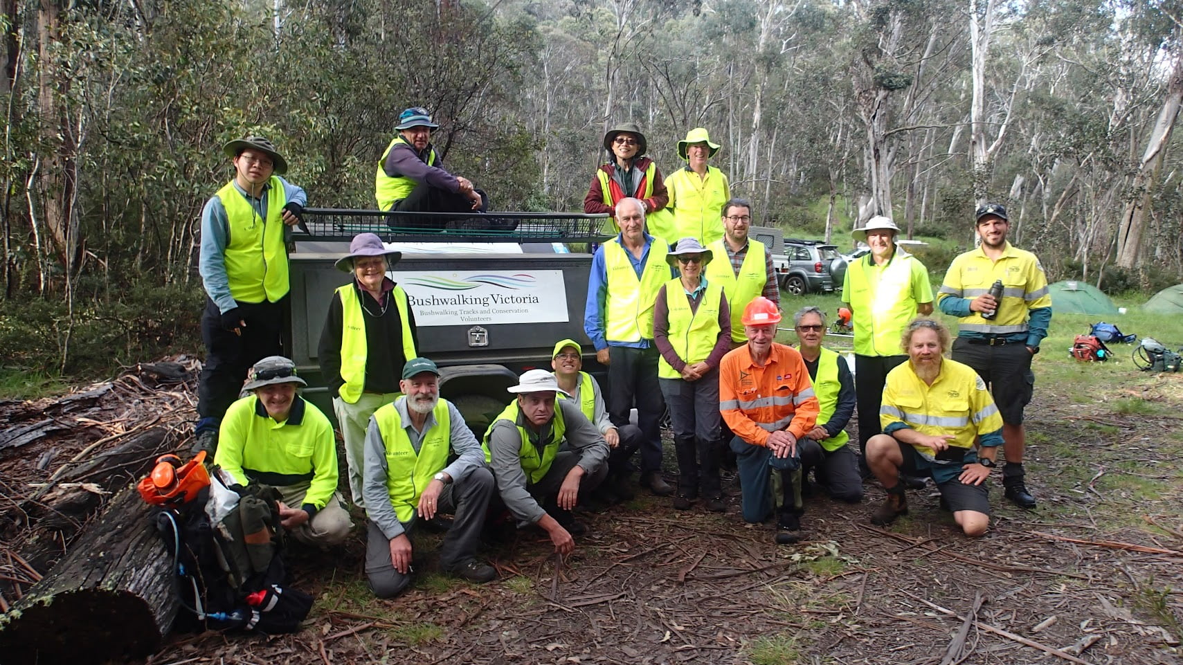
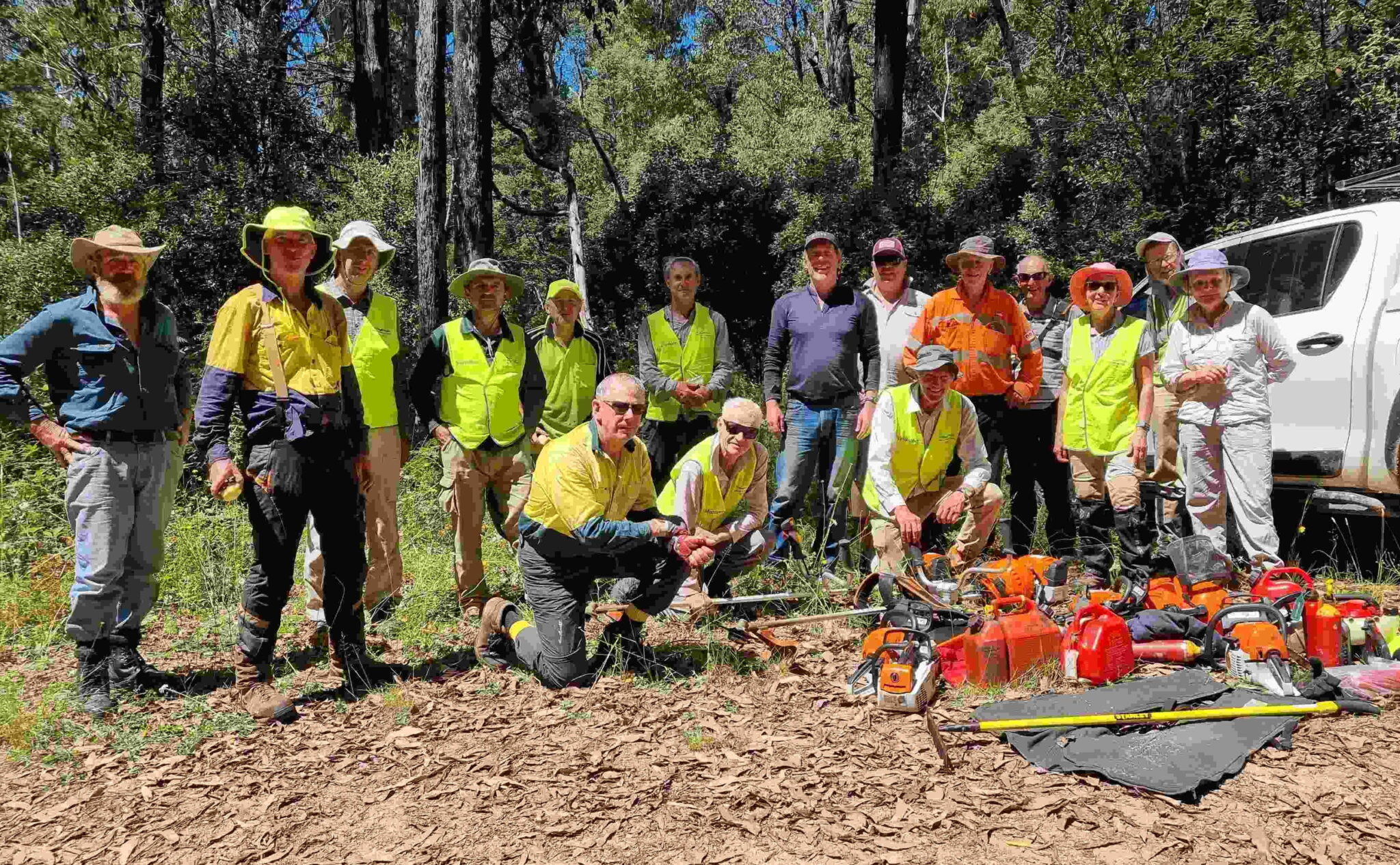
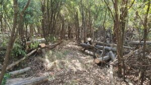
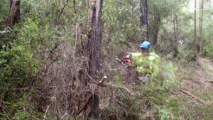
The BTAC February track clearing event involved clearing a section of the Australian Alpine Walking Track from Mt Sunday to Low Saddle in the northern extension of the Mt Skene Natural Features and Scenic Reserve. This relatively small section of track is only 3 kms but has had a reputation for being very challenging due to the large amount of fallen trees and growth that made the route indistinct.
Twenty keen volunteers fronted at the 7.30am safety briefing at the Mt Sunday helipad on Saturday morning. This in itself was no small task with many poor sections on the access roads due to rain damage, a tree down at Low Saddle (which Parks Vic cleared as cars waited to get through) and a steep 4WD climb to the helipad campsite. Thanks to the number of chainsaw operators that volunteered and their experience we made good progress into the fallen timber and reached Low Saddle by early afternoon on Sunday. This was well beyond expectations and a credit to the team work and great effort of the volunteers.
For a rather exposed mountain top, the weather was pleasant on the Mt Sunday helipad which allowed good community social time under the alpine stars with the lights of Buller in the distance. Thanks to Jim Craven, Parks Vic who dropped off gear and supplies for the BBQ and the volunteers who helped in the preparation and cooking.
Below images show Before and After shots!
I would like to thank all the volunteers who worked so hard and supported each other so well to get the job done. The posting on the BTAC Facebook page received some great comments that show the appreciation of the walking community:
“Big, big effort and thanks. That section was a commando training course before this. Amazed you have been able to clear it so quickly. Lots of hard work”.
“Wow, legends! any FKT attempt just got 3h faster”
“Makes you want to go back and do it again knowing where the track is this time”
“Thanks for the great work! It’s a small part of the track with a notorious reputation. I’m sure those that pass through will appreciate your efforts.”
On 31st January 2023, West Gippsland Bush Walkers Inc celebrated 25 years of its incorporation. The celebration, which was held at Mt Worth Moonlight Picnic Ground, was attended by over 70 people including current and former Club members, representatives of Baw Baw Shire, Friends of Mt Worth, Parks Victoria and Warragul and Drouin Gazette. One of the highlights of the event were presentations of two long standing members who reminisced on the Club beginnings. The formal part of the celebration was followed by sharing of a designer cake decorated with the Club logo.
West Gippsland Bush Walkers Inc was formed on 10th February 1998 after an adult education organization, Warragul Proceed, was disbanded. The members of the informal group decided to continue walks as part of an autonomous organization affiliated with the Victorian Federation of Bush Walking Clubs. Some of the original members of the Proceed group still remain as active members today. The Club uses the same logo that was designed 25 years ago “ADVENTURE, FRIENDSHIP, FITNESS” which perfectly describes the spirit of the organisation.
Every fortnight West Gippsland Bush Walkers Club offers three levels of walks with about 45 members attending. The Ramblers generally walk 7 to 10 kilometres on well-formed tracks at a slower pace than the other two groups. The Hikers walk 10 to 14 kilometres at a faster pace, usually on more challenging terrain than the Ramblers. The Trekkers generally walk 15 to 20 kilometres and engage in more challenging walks, with steeper terrain and elevation changes of up to 600 metres.
Apart from regular walks, every year Club members organise two weeks away, a bus trip, a Club BBQ and Christmas dinner. Past locations of weeks away have included Mornington Peninsula, Apollo Bay, Mallacoota, Jindabyne and New Plymouth in New Zealand.
Some of the significant Club achievements include receiving, in 2019, the Victorian Senior of the Year Award in the Age Friendly Victorian Award category, as well as securing several government grants to help fund its activities.
The Club co-operates with Friends of Mt Worth, Parks Victoria and DEECA, and takes part in clearing and maintenance works at Mt Worth and Bunyip State Parks.
More information about West Gippsland Bush Walkers Inc activities can be obtained through the Club website https://wgbwc.clubexpress.com/
The South Gippsland and Strzelecki clubs recently joined forces for a 5 day circuit hike from Falls Creek to Hotham. Looking at these photos it seems the weather was perfect and by all accounts a good time was enjoyed by all.
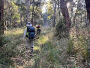
Fourteen BTAC volunteers worked with Parks Victoria to improve walking access to Tali Karng from the Tamboritha Road in January 2023. They made improvements to the many river crossings on the Wellington River to make navigation easier, cleared overhanging vegetation and did some work on the Riggall Spur Track, but the main emphasis was clearing the overgrown 6.5 km Clive Lanigan Memorial Track through the Valley of Destruction terminating at Tali Karng. It wasn’t all hard work, there was great camaraderie at the camp and volunteers were entertained by the antics of a small black platypus in the Wellington River adjacent to the camp site.
This was a logistically challenging activity with weather and access tracks needing to be dry for the activity to go ahead. It was clear a few days out that the conditions were favourable and that the contingency work would have to wait for another day. The volunteers gathered at Muttonwood Camp on the Wellington River north of Licola on Australia Day ready for an early start next morning to get to and establish camp at the base of Riggall Spur Track, 13km upstream from Tamboritha Road.
On the Friday morning participants parked their vehicles at the Platypus Camp and walked with day packs up the Wellington River, attending to river crossing improvements with hand tools, to the camp site. All camping gear, supplies for the weekend, tools, equipment and PPE were transported to the camp site by two Parks Victoria vehicles which negotiated a network of 4WD tracks, including Management Vehicles Only tracks, to get to the camping spot. A few volunteers scored a ride on the vehicles. Brush cutters were used to clear sufficient area for all the tents and amenities.
Saturday’s forecast was for temperatures into the 30’s so it was an early 7:00am start and an early finish for the two work teams. All workers were back in camp by 2:30pm to make full use of the river and shade to keep cool. It was during the afternoon that Meredith sighted the little platypus as it made its way upstream time and time again, sometimes leaving the water, just to be swept downstream by the current again to a pool created by a log across the river. Parks Victoria rangers provided the volunteers with a sumptuous BBQ for the evening meal.
Sunday and Monday were long days as each day the walk to the start of work and return from knock off position was longer. Fortunately these days were cooler, but still a bit humid. It was heavy work to clear the track of vegetation and fallen logs among all the rocks. The lake, Tali Karng, was reached around 2:30pm on Monday, mission achieved. That night the volunteers slept well with the satisfaction of a job well done.
On Tuesday the camp was packed up and everything stowed on the Parks Victoria vehicles for the journey back to the cars at Platypus Camp. The majority of the volunteers walked the full distance back to the cars with some still having enough energy to do some track clearing with hand tools along the way. The team contributed some 650 volunteer hours to achieve the objective.
Many thanks to the Parks Victoria Rangers, Tehan, Bek and Sam for their hospitality, facilitation and support. Thanks to Patrick for leading the second team and thanks to all the participants for their dedication to the task and their camaraderie throughout the six days.
Walkers, skiers and horse riders using the Australian Alps Walking Track (AAWT) will be pleased with the improved track along The Long Spur linking Mt Bogong and Mt Wills. Sixteen BTAC volunteers supported by two Parks Victoria Rangers cleared logs and densely encroaching vegetation, contributing 550 volunteer hours over the weekend. Read more HERE
“There was a good feeling of camaraderie among the group, all working together so efficiently to see such a length of track cleared to such a high standard”. John Green, Project Leader
It all began with a suggestion by a club member as Essendon Bushwalking Club members sat in the Star Hotel in Yackandandah in September 2016. They were celebrating the finish of the 635km Goldrush Walk which had kept them busy since they left Geelong in early December 2010.
“What should they do now?” was the question. Were these walkers mad, leader Bill Casey thought? After all the physical and psychological blood, sweat and tears they had endured on the Bay to Border (2002-2006), Melbourne to the Murray (2008-2016) and Goldrush Walks, not to mention twenty years of annual marathon walks (42km per day), surely it was time to back off a little and be happy with simple 10 to15 km day walks.
How far was it? How long would it take? Would enough walkers be interested?
In early 2017, armed with “The Major Mitchell Trail” guide published in 1990 by DCE (the predecessor of DELWP), together with copies of Mitchell’s own maps and notes, Bill and partner-in-crime Sue headed for Passage Camp on the Murray a few kilometres downstream from its junction with the Murrumbidgee. This was where Mitchell had crossed into what is now Victoria on 13 June 1836.
They spent a week exploring mainly by car the walking route possibilities from there to south-west of St Arnaud. Apart from a few worrying moments on the rough and muddy vehicle tracks along the Murray River flood plains, the driving was easy, and they were able to drive and explore long distances in short time. Following Mitchell’s track closely would sometimes involve sections of busy highway walking, so where possible they would seek nearby back roads.
A plan evolved to spend 5 consecutive days on the walk, 3 times a year, aiming to cover 90-100km each trip. The fifth day was effectively half a day, leaving the afternoon for travel home, so an average day’s walk was about 20km.
The next task was to select accommodation places for each stage. For stage 1 they discovered a little-known place called Tooleybuc, just across the Murray in NSW, part way along the stage 1 route. Subsequent accommodation spots for the first half of the walk were Swan Hill, Kerang, Boort and St Arnaud.
So the first five stages came and went between August 2017 and May 2019. Distance covered so far was 420km.
Some highlights of this first section were the Murray River, the inland lakes in the Swan Hill and Kerang areas, and the side-trip ascents of Mt Hope and Pyramid Hill, just as Major Mitchell had done. Did someone say the main highlight was the vanilla slices at the Leitchville bakery?
Next exploratory trip was to Horsham to work out a route from St Arnaud to Portland. The relatively flat terrain continued to Harrow, but then they found the deep river valleys which were encountered southwards to Dartmoor, meaning that the walkers would have to work a little harder. Accommodation venues were chosen: Stawell, Horsham, Edenhope, Casterton and Portland.
Stages 6 and 7 went without any major problems and included a side-trip to Mt Arapiles, but then COVID appeared. The caravan park at Edenhope must have been sick of us booking and then cancelling. On the third try in March 2021 they finally completed stage 8, and looked forward to plain sailing on to Portland. However, this was not to be as halfway through stage 9 in May 2021 they were forced to abandon and return home as John had visited a COVID “hot spot” a few days before coming to Casterton.
Further lock-downs meant that they were unable to complete stage 9 (renumbered stage 10) until May 2022. To avoid long walks on the busy Princes Highway between Dartmoor and Heywood, they had to engage in lengthy correspondence with VicTrack and a plantation manager before theywere able to walk through their lands.
The final stage 11 to Portland took place in August 2022. They had planned to keep away from the Princes Highway as much as possible, but flooded and closed minor roads forced us to “run the gauntlet” in single file and in our hi-vis vests – a not pleasant experience.
Highlights/lowlights of the second half included the pleasant walking beside the Wimmera River, the arduous stretches of deep soft sand in hot conditions in Tooan State Park and Konnepra State Forest near Miga Lake, historic Harrow township, many electric and barbed wire fences which had to be negotiated in the old railway reserve near Dartmoor, the “koala epidemic” north of Portland (as it was described by a local farmer), and the final pouring of Murray River water into Portland Bay. They then enjoyed a farewell dinner at Portland’s Royal Hotel.
Four walkers (Sue B, Chris B, John P and Bill) completed all 11 stages of the 880km walk with many more doing at least 90%.
Stay up-to-date with the latest Bushwalking News
Recieve the very latest Bushwalking News by entering your details below...


 This was a logistically challenging activity with weather and access tracks needing to be dry for the activity to go ahead. It was clear a few days out that the conditions were favourable and that the contingency work would have to wait for another day. The volunteers gathered at Muttonwood Camp on the Wellington River north of Licola on Australia Day ready for an early start next morning to get to and establish camp at the base of Riggall Spur Track, 13km upstream from Tamboritha Road.
 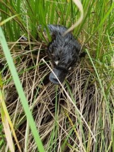 On the Friday morning participants parked their vehicles at the Platypus Camp and walked with day packs up the Wellington River, attending to river crossing improvements with hand tools, to the camp site. All camping gear, supplies for the weekend, tools, equipment and PPE were transported to the camp site by two Parks Victoria vehicles which negotiated a network of 4WD tracks, including Management Vehicles Only tracks, to get to the camping spot. A few volunteers scored a ride on the vehicles. Brush cutters were used to clear sufficient area for all the tents a