Posted on

Map Apps and Digital Apps

Map apps with digital maps are available for mobile phones, tablets and laptops. The GPS function on the device shows the current location on the selected map.  In effect it operates the same as a handheld GPS.

Google Maps is the everyday example of a map app. However Google Maps “terrain view” has limited detail for bushwalking purposes.

Other map apps provide much better topographic maps for bushwalking, from a variety of sources. Read More HERE

Posted on

The Best Stretches for Hiking!

Stretching before a hike is essential for preparing your body for the physical activity and reducing the risk of injury. Hiking involves a lot of physical exertion, including walking, climbing, and descending on uneven terrain. By stretching before a hike, you can increase your flexibility, improve your range of motion, and enhance your muscle function, which can all help to improve your performance and reduce the risk of strain or injury. Read More HERE

Source: Summit Strength

Posted on

The Wonder of the Western Port Woodlands!

In one of the most cleared regions of the most cleared state is an oasis of native vegetation. The Western Port Woodlands is the largest remnant of intact coastal woodlands in the region. The Woodlands comprise five small reserves and patches of private land. It stretches from Lang Lang to Grantville on the eastern shore of Western Port Bay.

The VNPA’s Wildlife corridor or sand pit? report found these connected patches of bush are both rare and critical. They’re home to many threatened wildlife and habitats – Southern Brown Bandicoots, fungi and Australia’s largest owl, the Powerful Owl.

But right now, it’s under threat from sand mining. Read more HERE

Source: VNPA

Posted on

Deer Control Programs

Parks Victoria is responsible for conservation management to restore and protect park habitat, including the control of introduced plant and animal species.  Deer control programs programs are occurring in the following parks:

Bunyip SP and Kurth Kiln Regional Park – November 2022 – June 2023

Following the 2019 bushfires Parks Victoria has observed large numbers of deer within the park. A controlled, safe and humane deer control operation will occur up until June 2023. Signs will be displayed at entrance ponts to control zones.  For more information and area map read HERE

Baw Baw National Park 5-11 March 2023

Parks Victoria will engage the services of a contractor to undertake deer control in the Baw Baw National Park on 5-11 March 2023, dependent on weather conditions. The park will not be closed when deer control work is being undertaken. Signs will be placed at major access points advising visitors that deer control is being undertaken. For more information and area map read HERE

Posted on

Parks Victoria – Deer Control Program – Baw Baw National Park

Parks Victoria will engage the services of a contractor to undertake deer control in the Baw Baw National Park on 5-11 March 2023, dependent on weather conditions. The above map shows the area in which deer control will occur.

The park will not be closed when deer control work is being undertaken. Signs will be placed at major access points advising visitors that deer control is being undertaken. All personnel involved will be working under the supervision of Parks Victoria staff. They will be readily identifiable and will act in accordance with all legal requirements to ensure the safe use of firearms. Over the past decade there has been a significant expansion of deer across Victoria and of particular concern is the increasing deer activity at higher elevations. Baw Baw National Park is home to high quality, relatively intact, alpine peatlands and deer presence has a significant impact on the resilience of alpine peatlands.

Alpine Peatlands and Associated Fens are an endangered ecological community listed under national and state legislation (the Commonwealth Environmental Protection and Biodiversity Conservation Act (1999) and Victorian Flora and Fauna Guarantee Act (1988)). They provide a critical hydrological function at the top of the water catchment, filtering water and modulating flows. Alpine peatlands also provide habitat for several threatened species including the alpine water skink, alpine she oak skink and Baw Baw frog.

Deer pose the greatest threat to alpine peatlands by trampling, wallowing, grazing and thrashing their antlers to remove vegetation. A recent study by Davies et al. 2020 used a camera array to confirm anecdotal information that Sambar deer are present in Baw Baw National Park.

The Alpine National Park Deer Control Trial (which concluded in 2020) has shown ground shooting using contractors is an efficient and effective approach for controlling deer in the alpine environment. Parks Victoria takes coordinated action, informed by scientific research, tailored to individual parks and target species, to reduce the damage caused by deer and feral animals. Each conservation program is one of hundreds of programs across Victoria using available tools to protect nature.

Please contact Parks Victoria if you have any questions or would like more information on this project at conservation@parks.vic.gov.au, or call 13 1963

Posted on

Check your Map!

There are some really good hiking apps out there, but many are updated by people who don’t have an intimate knowledge of the local terrain, and they can feature uncorroborated information. A recent incident in the UK could just as easily have occurred in Victoria.

Here is an excellent article that underlines how important it is for walkers to use proper navigation techniques and equipment, and not rely entirely on information supplied by individual apps.  READ MORE

(Image credit: Keswick Mountain Rescue)

Posted on

Tips for Summer Bushwalking

Summer brings unique challenges; here are some tips for making bushwalks in summer enjoyable and safe.

Choose your walk carefully

  • Summer can be scorching, so choose a walk to suit the weather.
  • Avoid desert walks; look for routes that provide some shade.
  • Avoid any walk that involves steep climbs during the hottest part of the day.
  • Locations such as the Goldfields, Brisbane Ranges, Werribee Gorge, Long Forest and Lerderderg Gorge are not generally recommended for summer walks.
  • Consider the cooler Alpine areas or rainforest areas such as the Otways, the Central Highlands, East Gippsland, Strzelecki Ranges and Wilsons Promontory.

Be prepared

  • Check fire warnings before you set out. Cancel your walk if the weather forecast is Catastrophic/Code Red or Extreme. Victorian parks and forests in bushfire-prone areas are often closed to the public on Code Red days.
  • Plan to start your walk early in the morning to avoid the hottest part of the day.
  • Wear light colours, long sleeves and lightweight loose-fitting clothes to facilitate sweat evaporation.  Don’t forget your hat, sunscreen and sunglasses.
  • Carry plenty of water. Safe, naturally-occurring drinking water is generally non-existent in the bush in summer.
  • Learn to identify the symptoms of heat exhaustion and know how to treat it.
  • Don’t forget your first aid kit, including snake bite bandages just in case!

During the walk

  • Stay well-hydrated before, during and after your walk and consider carrying extra electrolytes to replace those lost when you sweat.
  • Allow time for a slower pace and to have more frequent drink and rest stops.
  • If you’re doing a long walk, either take a lengthy midday break or see if you can reduce the distance to be covered.

You can find more detailed information about trip planning, dealing with extreme weather, walking in challenging conditions and minimum water requirements in the Bushwalking Manual.


Posted on

Stay Safe in Nature – This Summer is Different!

In response to ongoing flooding and unpredictable weather across the state, Parks Victoria has commenced a new safety campaign for the Christmas holiday period – this Summer is Different!

Current situation

Storm and flood damage to our parks is widespread. Some parks are still underwater, in others the waters have receded but there are significant risks from falling trees, water crossings, flash flooding, pot holes, landslips and more.

There is also significant damage to roads, tracks and visitor facilities managed by Parks Victoria as well as the environment and cultural heritage.

With more weather events expected over the summer period, the emergency is ongoing, constantly changing and challenging.

Parks Victoria’s priority is to keep people safe while visiting parks.

Their key message to people is check the condition of a park before you go and plan your trip accordingly.

Key places for information:

Posted on

Training 2023

Workshops: Using your Smartphone for Navigation

Westerfolds Park, Fitzsimmons Lane, Templestowe.
Sundays, March 12 or April 2, 9:00 am to 3:00 pm

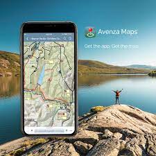
In this Workshop we will look at how GPS satellite navigation works – the theory, practicalities, advantages and limitations. We will discuss a variety of free smartphone mapping/navigation apps, including Avenza, maps.me, and Terra Map. An outdoor practical exercise will be included. Detailed notes, activity sheets and map will be supplied.

These workshops are open to all club members and Individual Bushwalking Victoria members.

Registration for the March 12 Workshop opens at 9.00am on Saturday February 4 via this link.
Registration for the April 2 Workshop opens at 9.00am on Saturday February 18 via this link.

When registering online, you will need to provide your Name, Mobile Number, Club or Individual BWV Member status and Make and Model of your Smartphone.

Enquiries: bushnavigationandmaps@iinet.net.au

IMPORTANT: After registration, successful applicants will be provided with information on what to bring. They will also receive detailed instructions on phone setup. Preparation and pre-reading MUST be completed BEFORE the workshop. You must already be familiar with basic map/compass navigation and be conversant with your own smartphone e.g. be able to update software and install new apps.