Distance: 16 Km | Duration: 4.5 Hrs | Grade: Grade 3 | Rating: | Style: Circuit | Map
About the Walk
Overview
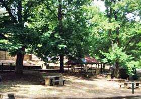
This walk visits the Vaughan Mineral Springs picnic ground on the banks of the Loddon River. Alluvial gold was discovered there in July 1851 and with an influx of Chinese miners a township called The Junction was formed together with a market garden. By the end of the nineteenth century gold mining had declined in the area. However mineral springs were discovered in 1910 and the area became a popular destination for health and recreation. Today mineral spring water can be sampled in the springs. The Tubal Cain mining complex with its horizontal chimney, dam building ruins and several open shafts are also visited along the track.
The Walk in Detail
Start the walk at the junction of Porcupine Ridge Road and Helge Track (Grid Reference (GR) 522803) and head north-east along Helge Track. The track winds for 1.2km over boggy areas and rough ground tothe intersection with the Great Dividing Trail (GDT) at Sailors Gully (GR 532804). Continue on Helge Track for a further 1.5km until it meets Italian Hill Track at GR 541811. Turn left onto Italian Hill Track and go uphill 1km to the slate quarry at GR 5288821, which is a few metres from the track on the left hand side.
Continue on thetack descending to the Loddon River andthe ascending on its left-hand side. AT GR 533826 walk north-east off-track for 1km. Follow along an old fence line then north-east along the ridge until it reaches a knoll. continue north-east along the ridge to the water race along the Loddon River (GR 540832). Walk a further 20m towards the Loddon River and, depending on the water level, cross it and arrive at Glenluce Springs. Return back to the water race andturn right (west). Walk along the water race to a fence (GR 532834) and turn right into a grassy area and walk between an old orchard and the river. Go back to the water race, which at GR 528822 meets the GDT 2.2km form the start of the water race. Walk on the GDT for 200m north and cross over the Loddon River on the weir wall to the Vaughan Springs picnic ground. From the picnic ground walk 500m north-west to the Chinese Burial Ground. Retrace your steps via the GDT (south) for 900m to the junctions with Italian Hill track (GR 528829). Continue south on Gurr Track until the GDT turns off Gurr Track at (GR 526821).
Turn left (south) on the GDT and wal for 1.4km to reach the Tubal Cain mining complex (GR 529810) on the right, and a dam on the left. Walk another 100m and take the right track, which is the water race alon Sailors Gully. The GDT meet Helge Track after 700m. Turn right (west) onto Helge Track and retrace your steps to the start of the walk.
Getting There
From the Base (Hepburn Primary School) turn right onto Main Road and follow this road east then south for about 4km to a roundabout in Daylesford. Turn left onto the midland Highway (A300) for about 2.2km then turn right onto the Daylesford-Malmsbury Road (C316) and stay on this road for 950m to Porcupine Ridge Road. Turn left and follow Porcupine Ridge Road for 18.1km, the last 7km of which is unsealed, to the junction with Helge Track and the start of the walk.Walk Precautions
Most of the tracks are vehicle tracks and can be very slippery in wet weather. Off-track sections and ill-defined track along the water race need care due to high grasses with the risk of snakes. At theTubal Cain mining complex there is a line of deep open shafts parallel to the track. Boots are essential on this walk, and gaiters and walking poles are recommended.
