Distance: 12 Km | Duration: 8 Hrs | Grade: Grade 4 | Rating: | Style: Return
Best Season: Summer, Autumn, Spring
About the Walk
Overview
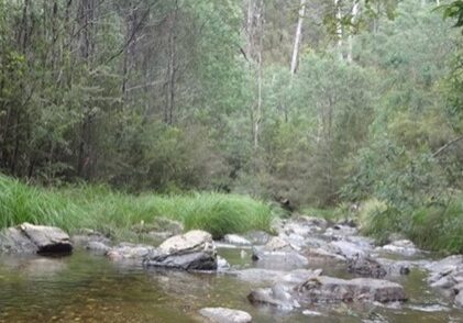
This walk along a section of McMillans Walking Track, will take you to one of the most serene and isolated spots in the Victorian high country at the picturesque Black River. To get there, we walk through delightful, cool, temperate Alpine Ash forest and dry sclerophyll forest dominated by Messmate and Red Stringybark. We walk along a benched track, supported in places by dry stone walling, and pass trees containing blazes, evidence of the work of McMillan's work gang in 1864.
The Walk in Detail
From Lazarini Spur Track, turn left onto an old, overgrown logging road following red triangular McMillan Walking Track markers. This section of MMWT was cleared and rejuvenated in 2019. The track initially commences in Alpine Ash forest, but quickly moves into dryer vegetation dominated by several gum species before verging into typical dry sclerophyll forest dominated by Messmate Stringybark, Red Stringybark, and Peppermints. Several bushfires have ravaged the area over the past 20 years and there are often dense areas of Acacia understory. Follow the walking track southwest, descending along the crest of a spur for 3km, we pass some large trees with old blazes reputably created by McMillan’s original work party back in 1864. The walking track eventually leaves the spur and heads southeast, crossing some gullies where there are benched sections of miners track and dry-stone walling also constructed by McMillan’s crew. This leads onto another spur which descends southwest. The benched track doubles back to the northwest, crossing more gullies, then descends into the Black River. This is the lunch stop before the return journey back up the way we have come. Sturdy footwear, gaiters and poles are recommended. Walkers should also become prepared for alpine weather and carry appropriate clothing and adequate water.
