Distance: 11.5 Km | Duration: 5 Hrs | Grade: Grade 2 | Rating: | Style: Circuit | Map
About the Walk
Overview
A mostly flat walk along the delightful Upper Yarra River with a chance to see historic Warburton Township and have lunch there.
The Walk in Detail
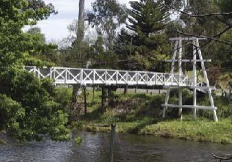
Starting / finishing at Melway 290 H3, follow the riverside track west through bush then the caravan park. Continue under the highway bridge, then use the footpath to cross the river. Take the trail on the south side of the river through a stand of California redwoods, then cross Redwood Bridge and take a detour to Riverview Lookout and return (500m). Continue on the north side of the river past Bramich Bridge, Brisbane Bridge, Swing Bridge and then Mayer Bridge at the downstream end of Warburton.
Cross over Mayer Bridge to Scotchmans Creek Road and pick up the signposted track up to Dolly Grey Park. The park area is approximately 0.4 km from the highway, then continue uphill on Backstairs Track for 0.25 km to a junction and turn right to return to the highway. There are some short, steep uphills in this section. The short, steep descent can be slippery if conditions are wet. Cross the highway again at Mayer Bridge to pick up the riverside walk for 0.9 km to the public toilets. Take a pathway up to the highway and shops to the Visitor Centre and the Railway Station. Also, visit the Mural Wall.
Return via the pathway to the riverside walk, turn right and continue around the football ground to Redwood Bridge. From here the walk retraces the previous route back to the cars.

