Distance: 15 Km | Duration: 6 Hrs | Grade: Grade 3 | Rating: | Style: Circuit | Map
About the Walk
Overview
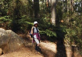
This walk features beautiful, tall and straight mountain ash forest, many tree ferns, an apple orchard, and views of the Little Yarra Valley.
The Walk in Detail
From the parking area walk back a couple of hundred metres along Britannia Creek Road and turn left up the Silvertop Track. Cross Britannia Range Track onto Condon Track, then turn right at Coppice Track and left into Buffer Break Track. This track curves around to the southwest through an apple orchard, to Tarrango Road. Turn left onto Ellis Track.
After a steep climb the route heads right onto Britannia Range Track. After about 200m veer left off the vehicle track (opposite a bulldozed clearing) along a partly overgrown foot track to emerge at the junction of Britannia Range Track, Portas Track and Lady Walker Track. Head left down Lady Walker Track which changes from a road to a foot track after a few hundred metres. After a long descent go left into Britannia Creek Road for 1km to the cars.
Getting There
From the Warburton Visitor Centre, drive 7 km west on the Warburton Highway (B380) to Wesburn, turn left into Britannia Creek Road. After 5 km, keep left at Guidehouse Road, Bundaleer Road and the next intersection. Keep right at the Britannia Creek Falls turnoff. After Guidehouse Road (about 2 km in), the road becomes winding, with gravel, mud and some potholes (take care). Park on the left in the large open area at the junction of Britannia Creek Road and Justice Track, taking care not to get bogged if wet. Distance 12 km, 20 minutes.Walk Precautions
There is a challenging climb past large granite boulders and very deep erosion gullies. Foot tracks pass through lush regrowth forest. Walking poles and boots are highly recommended.
