Distance: 11 Km | Duration: 5 Hrs | Grade: TBA | Rating: | Style: Circuit | Map
About the Walk
Overview
While this walk is to a seldom visited hut on the Baw Baw plateau, this route passes a number of the iconic points of interest to be found on the eastern end of the plateau.
The Walk in Detail
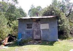
While this walk is to a seldom visited hut on the Baw Baw plateau, this route passes a number of the iconic points of interest to be found on the eastern end of the plateau. The walk starts at the Mt Erica car park and travels in a northerly direction along the Australian Alps Walking Track for 2 km to Mushroom Rocks. This is an ideal place to have morning tea and explore these giant granite boulders. From here continue along the Australian Alps Walking Track until reaching a cleared area. Leaving the Australian Alps Walking Track and veering to the right, contour through light bush until we reach NBW hut. After checking out the hut, continue off track to the summit of Mt Erica. Re-join the Australian Alps Walking Track and head in a south westerly direction back to the car park.
Getting There
From Moe, 130 km East of Melbourne on the Princes Highway, drive to Rawson 36.2 km amd 41minutes from Moe. Take the Moe-Walhalla Road C466, turn right onto Knotts Siding Road C481.
From Rawson, travel to the Thomson Valley Road. Turn right and travel about 8kms to the Mt Erica turn off on your left. Follow this to the car park at the end of the road. The walk starts here.
Walk Precautions
This is an alpine area. Snow and cold weather can occur at any time of year.
