Distance: 16 Km | Duration: 6 Hrs | Grade: TBA | Rating: | Style: TBA | Map
About the Walk
Overview
The walk is gently uphill from the Mt St Gwinear car park, along parts of the Alpine Walking Track to Mt Erica and on to the Mt Erica Car Park. The track passes through a variety of eucalypt forest.
The Walk in Detail
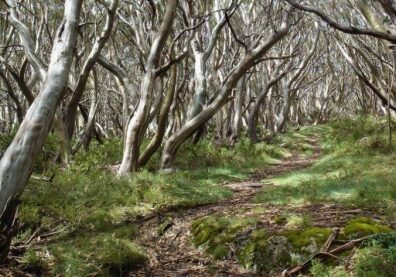
The walk is gently uphill from the Mt St Gwinear car park for about 4 km to the Australian Alps Walking Track at the Rock Shelter. From there, the track undulates through Snow Gum (Eucalyptus pauciflora, subspecies acerina) woodland, with one patch of Myrtle Beach (Nothofagus cunninghamii). There are some long climbs in places.
We pass an old hut site that was established during the Depression by the Victorian Tourist Bureau but was destroyed in the 1939 wildfires. The trees we walk through are all regrowth from that fire.
After we pass Mt Erica, we descend steeply to Mushroom Rocks, a group of granite boulders with one pair that looks just like a giant mushroom. As we descend the trees gradually change from Snow Gums to Alpine Ash (Eucalyptus delegatensis) and Shining Gum (Eucalyptus nitens) then Mountain Ash (Eucalyptus regnans). Just past the Rocks we pass a few Tingaringy Gums (Eucalyptus glaucescens). The last section of the track traverses a magnificent stand of Mountain Ash, Shining Gum and some pure stands of Silver Wattle (Acacia dealbata), all 75 years old, having regenerated naturally from the devastation of the 1939 wildfires.
Getting There
From Moe, 130 km East of Melbourne on the Princes Highway, drive to Rawson 36.2 km and 41 minutes from Moe. Take the Moe-Walhalla Road C466, turn right onto Knotts Siding Road C481. From Rawson, travel up the Thomson Valley road and leave some cars at the Mt. Erica Car Park and others at the Mt. St. Gwinear Car Park, where the walk begins. The total distance involved is about 33 km car travel from Rawson, including the car shuffle.Walk Precautions
This walk is graded hard and is above the snow line so be prepared for cold weather.
