Distance: 16 Km | Duration: 6 Hrs | Grade: Grade 2 | Rating: | Style: Circuit | Map
About the Walk
Overview
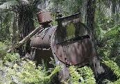
This walk features tall mountain ash, rainforest, and magnificent ferns and creeks. The 76 metre Ada Tree is one of the tallest mountain ash in Victoria and is over 300 years old. The area has many saw mills and tramways: New Ada Mill; New Federal Mill; and especially the Ada No. 2 site with its spectacular old boilers and machinery.
The Walk in Detail
From the cars walk 2.4 km west along Big Creek Road to the VHC Track. The path to Federal Crossing has new tracks not on the maps. Turn left on VHC Track keeping left after 0.9 km on the smaller track, then pass a revegetation area. After 0.9 km turn left again following the walking track sign, in 200m pass a sign for the New Ada Mill site (no trace), its then 1.4 km past our first mill machinery to Federal Crossing (a four ways intersection for old tramways).
Proceed south (signed High Lead) to the Ada No. 2 Mill site. This is a good place to have a break, explore the extensive mill remnants, and the bridge over the Ada River 150m further on. Return to Federal Crossing and turn east (right) for the New Federal Mill site and Ada Tree. There is a stone crossing over the Little Ada River (the old bridge is too dangerous) which may be difficult after heavy rain. From the mill site turn left following the signs for 1.4 km to the Ada Tree.
From the Ada tree take the path “Return to Car Park 1.5km” through the Island Creek Rainforest. Then follow Ada River Road north for 1.6 km to the unnamed left track at GR002150 (a sign points to the Ada Tree). Cross the earthworks that prevent vehicle access and follow the track for 3km first downhill then climbing 100m to the cars.
Getting There
Drive east from the Warburton Visitor Centre on the Warburton Highway (B380) and Woods Point Road (C511) for approx. 11km then turn right into well formed 4WD / gravel Brahams Road.
Follow it for 13km to the T junction with Big Creek Road generally keeping left at each junction.
Turn right and 200m later park the cars on a right hand bend near the Federal Road Short Cut (closed to vehicles).
Travel time is approx. 30 minutes.
Walk Precautions
Gaiters and walking sticks are useful.
